LARGE IMAGE OPENS IN A NEW WINDOW
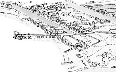
The first vessel to be constructed at Lyttelton was launched from the port's earliest slip-way close to where the former railway station now stands, adjacent to where she is depicted below at the lower Right.
With a displacement of 20 tons and the registration number 40337, she was also reputed to be the first New Zealand vessel built of indigenous timbers. Constructed by the Scottish emigrants John Grubb (1817-1898) and George Marshall (1821-1874), the light displacement cutter was christened Caledonia by Mrs Mary Grubb at 1 pm on Wednesday, the 31st of August, 1853.
With her shallow draft, the gaff-rigged Caledonia appears to have been built specifically for the coastal river trade. Although her hold had the capacity to carry about 30 bales of wool, her principal role would have been to carry both construction timber from George Marshall's sawmill at Pigeon Bay and the early emigrant's heavy luggage from Lyttelton to the wharves at the port of Christchurch on the Heathcote River at Woolston.
The ship building partnership with George Marshall appears to have been a short-lived affair, as two years later John Grubb is listed as being in that business with the Shipwrights Robert and Magnus Allen, also of Lyttelton. However, it's recorded that George Marshall's younger brother, Captain John Wallace Marshall, was a trusted Heathcote River pilot. The Captain is also listed as the Master of Grubb and Marshall's second vessel; the steam lighter Canterbury, which they built at Pigeon Bay in June 1855.
During her short career the Caledonia encountered at least four significant mishaps, with the last being fatal.
The first occurred at the end of 1856, when her Master and seaman Marsh were drowned when the ship's boat, laden with bales of wool, capsized at Boat Harbour, 15 kms south of Kaikoura. The well known and much esteemed Captain Randal had been a crew member of the Charlotte Jane, first of the Canterbury Association's emigrant vessels to arrive at Lyttelton in 1850.
In July 1863 the Caledonia was bumped on to a sand bank by a heavy roller when crossing the Bar at nearby Sumner. The vessel's main mast snapped just above the deck and Edward Newton promptly jumped overboard in time to save himself from being struck by it. William Callaghan, the other crew member, was however not so fortunate. At the helm, he was knocked unconscious when struck violently by the masthead.
At some unspecified date, probably as a consequence of the great tidal wave of 1863, the vessel was driven ashore at Little Akaloa in Akaroa Harbour while employed in carryinging timber to Lyttelton.
Caledonia's final mishap came on the 16th of April 1866 when she struck the treacherous rocks below Whitewash Head, which stands between Taylors Mistake and Sumner (below).

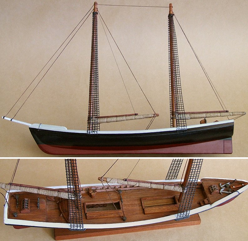
The carvel planked scale model of the Caledonia was built using the vessel's indigenous woods and extensively copies her original construction methods. The model is 43 cm in length, 34 cm above the keel and carries the barely decipherable inscription "Caledonia 1853" on the base of the pedestal.
With a displacement of 20 tons and the registration number 40337, she was also reputed to be the first New Zealand vessel built of indigenous timbers. Constructed by the Scottish emigrants John Grubb (1817-1898) and George Marshall (1821-1874), the light displacement cutter was christened Caledonia by Mrs Mary Grubb at 1 pm on Wednesday, the 31st of August, 1853.
With her shallow draft, the gaff-rigged Caledonia appears to have been built specifically for the coastal river trade. Although her hold had the capacity to carry about 30 bales of wool, her principal role would have been to carry both construction timber from George Marshall's sawmill at Pigeon Bay and the early emigrant's heavy luggage from Lyttelton to the wharves at the port of Christchurch on the Heathcote River at Woolston.
The ship building partnership with George Marshall appears to have been a short-lived affair, as two years later John Grubb is listed as being in that business with the Shipwrights Robert and Magnus Allen, also of Lyttelton. However, it's recorded that George Marshall's younger brother, Captain John Wallace Marshall, was a trusted Heathcote River pilot. The Captain is also listed as the Master of Grubb and Marshall's second vessel; the steam lighter Canterbury, which they built at Pigeon Bay in June 1855.
During her short career the Caledonia encountered at least four significant mishaps, with the last being fatal.
The first occurred at the end of 1856, when her Master and seaman Marsh were drowned when the ship's boat, laden with bales of wool, capsized at Boat Harbour, 15 kms south of Kaikoura. The well known and much esteemed Captain Randal had been a crew member of the Charlotte Jane, first of the Canterbury Association's emigrant vessels to arrive at Lyttelton in 1850.
In July 1863 the Caledonia was bumped on to a sand bank by a heavy roller when crossing the Bar at nearby Sumner. The vessel's main mast snapped just above the deck and Edward Newton promptly jumped overboard in time to save himself from being struck by it. William Callaghan, the other crew member, was however not so fortunate. At the helm, he was knocked unconscious when struck violently by the masthead.
At some unspecified date, probably as a consequence of the great tidal wave of 1863, the vessel was driven ashore at Little Akaloa in Akaroa Harbour while employed in carryinging timber to Lyttelton.
Caledonia's final mishap came on the 16th of April 1866 when she struck the treacherous rocks below Whitewash Head, which stands between Taylors Mistake and Sumner (below).
The carvel planked scale model of the Caledonia was built using the vessel's indigenous woods and extensively copies her original construction methods. The model is 43 cm in length, 34 cm above the keel and carries the barely decipherable inscription "Caledonia 1853" on the base of the pedestal.


