LARGE IMAGE OPENS IN A NEW WINDOW
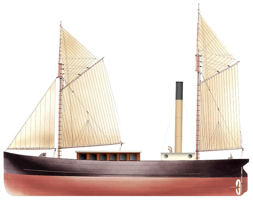
There are no known specific photographs of the Lyttelton coastal passenger steamer Gazelle. However, she appears in the distance in five photographs of the port taken between 1861 and 1879, and it's therefore been possible to recreate her original appearance with a reasonable degree of accuracy.
Screw driven steam ships were still something of a rarity in 1852 when the 78.85 ton vessel was launched by John Horn (1815-1895) from Malcomson's Neptune Iron Works at Waterford, Ireland. Early propellor designs were plagued with vibration and the paddle wheel driven steam ship remained more popular into the 1860s.
With a length of 25.17 metres, 4.95 metres in the beam and a draft of 2.35 metres, she was clinker built of overlapping iron plates, affixed with clench bolts. In the 6.75 metre engine room two diagonal direct acting 30 horsepower steam engines were geared to a single shaft. Built by Wilton & Company of Deptford, England, the engine cylinders were 36 centimetres in diameter, with a stroke of 46 centimetres.
The eventful career of the Schooner rigged vessel began in the ownership of Anthony G. Robinson of London, where she was registered in 1853. Sailed to Australia, she was sold in March, 1854 to Frederick Evelyn Liardet of Ballam Park at Sandridge, who used her for carrying the Royal Mail and overseas passengers from Port Melbourne to the city.
In April, 1857 ownership was transferred to Captain William Lushington Goodwin (~1798 -1862) of Launceston, who employed the Gazelle in the passenger trade between Launceston and Georgetown. On the 28th of August 1860 she was sold to a James Nichols, passing three days later Charles V. Robinson of Launceston and James Lilly of Melbourne for service between the coastal ports of south-west Victoria and Melbourne until September 1861. She then passed briefly to James Tobin Cockshott (1831-1867), a merchant of Melbourne.
But the longest chapter in Gazelle's career began with her arrival in the command of a Captain James at Lyttelton in October, 1861. Her new owner was Frederick Banks (1825-1894), of Heathcote, Christchurch. A partner with Murray Aynsley in the shipping agency of Miles & Co. on Norwich Quay, Banks had arrived from Melbourne in 1857.
In the service of Miles & Co., from November, 1861 Gazelle carried passengers, in two classes, from Lyttelton's Peacock's Wharf to the South Island coastal ports of Kaiapoi, Kaikoura, Akaroa, Timaru and Port Chalmers. Until 1863 she appeared in the command of Captain Thomas Gay, whose previous vessel, the whaling brigantine Corsair, had been wrecked at Lyttelton in April, 1861.
In March of 1863 the Gazelle stranded at Saltwater Creek in the Kaiapoi River estuary. By the Autumn of 1864 she was carrying miners to the gold fields at the head of Pelorous Sound in the Marlborough district.
By the later 1860s, economic depression and the development of the provincial railways precipitated a decline in the demand for coastal passenger services and Gazelle was plying Lyttelton Harbour carrying Immigration and Health Officers to overseas vessels entering the port and also acting as a tug and passenger tender.
Serving the port of Christchurch on the Heathcote River at Woolston by 1862, on Saturday, the 2nd of November, 1867 Gazelle ran ashore on the north spit when towing two ketches across the bar at Sumner. Expected to become a total loss, the wreck was sold to new owners (probably Talbot, McClatchie & Co.), recovered over a specially built way and rebuilt by Anderson & Grubb at Corsair Bay for £1,000 (the engine being rebuilt by John Anderson's Lyttelton foundry).
In 1868 the Port of Melbourne registry (40931) was tranferred to Lyttelton. In July of that year she salvaged cargo from the 163 ton brig Daniel Watson, which had been wrecked on the Shag Reef in Lyttelton harbour. On the 15th of August a Tsunami originating off the seaboard of Peru caused the Gazelle to break her moorings when a tidal surge swept up the Kaiapoi river. The steamer smashed into the wooden schooner Challenge as a consequence. But her greatest claim to fame came on the 22nd of April, 1869 when she conveyed Queen Victoria's second son from the 4,686 ton steam frigate Galatea anchored off Little Port Cooper into the township.
Although by the later 1870s she was still a sound sea-going vessel, Gazelle was facing stiff competition from newer and more powerful vessels in the Lyttelton service. In 1877 she undertook a five month salvage expedition to the General Grant, which had been wrecked on the Auckland Islands in 1866. Her master Captain Giles was able to locate the wreck, but no gold was recovered.
Six months later the little ship was inolved in a more successful salvage, recovering cargo from the wreck of the Ann Gambles in Bluff Harbour. But there was insufficient work for her in the South Island coastal trade and she was sold in April, 1879 to Reginald Bright of Melbourne. Re-registered there, a month later she was sold on to W. H. Wischer and Company, Superphosphate and Fertiliser merchants.
By March, 1884 Gazelle was owned by William F. Walker of the Waratah Bay Lime, Marble and Cement Company. Captained by John Brown, she plied in the Lime trade to Waratah Bay, Victoria and also called at other Gippsland ports to load general cargo. Subsequently cut down to a Lighter and with her engines removed, she was used by the Barham River Timber Company to carry timber to vessels loading in the crescent shaped Apollo Bay (located between Lorne and Cape Otway, 187 km southwest from Melbourne).
Succumbing to an easterly gale of the notorious Bass Strait weather, the Gazelle was swamped at her mooring and blown ashore in Apollo Bay on the 25th of February, 1889. Laden with railway sleepers, she would become one of the 16 known shipwrecks in the bay (of which only three have been identified).
Not quite forgotten across the Tasman Sea, her New Zealand sojourn is commemorated by the naming of Gazelle Lane in the Christchurch suburb of Redcliffs.
Screw driven steam ships were still something of a rarity in 1852 when the 78.85 ton vessel was launched by John Horn (1815-1895) from Malcomson's Neptune Iron Works at Waterford, Ireland. Early propellor designs were plagued with vibration and the paddle wheel driven steam ship remained more popular into the 1860s.
With a length of 25.17 metres, 4.95 metres in the beam and a draft of 2.35 metres, she was clinker built of overlapping iron plates, affixed with clench bolts. In the 6.75 metre engine room two diagonal direct acting 30 horsepower steam engines were geared to a single shaft. Built by Wilton & Company of Deptford, England, the engine cylinders were 36 centimetres in diameter, with a stroke of 46 centimetres.
The eventful career of the Schooner rigged vessel began in the ownership of Anthony G. Robinson of London, where she was registered in 1853. Sailed to Australia, she was sold in March, 1854 to Frederick Evelyn Liardet of Ballam Park at Sandridge, who used her for carrying the Royal Mail and overseas passengers from Port Melbourne to the city.
In April, 1857 ownership was transferred to Captain William Lushington Goodwin (~1798 -1862) of Launceston, who employed the Gazelle in the passenger trade between Launceston and Georgetown. On the 28th of August 1860 she was sold to a James Nichols, passing three days later Charles V. Robinson of Launceston and James Lilly of Melbourne for service between the coastal ports of south-west Victoria and Melbourne until September 1861. She then passed briefly to James Tobin Cockshott (1831-1867), a merchant of Melbourne.
But the longest chapter in Gazelle's career began with her arrival in the command of a Captain James at Lyttelton in October, 1861. Her new owner was Frederick Banks (1825-1894), of Heathcote, Christchurch. A partner with Murray Aynsley in the shipping agency of Miles & Co. on Norwich Quay, Banks had arrived from Melbourne in 1857.
In the service of Miles & Co., from November, 1861 Gazelle carried passengers, in two classes, from Lyttelton's Peacock's Wharf to the South Island coastal ports of Kaiapoi, Kaikoura, Akaroa, Timaru and Port Chalmers. Until 1863 she appeared in the command of Captain Thomas Gay, whose previous vessel, the whaling brigantine Corsair, had been wrecked at Lyttelton in April, 1861.
In March of 1863 the Gazelle stranded at Saltwater Creek in the Kaiapoi River estuary. By the Autumn of 1864 she was carrying miners to the gold fields at the head of Pelorous Sound in the Marlborough district.
By the later 1860s, economic depression and the development of the provincial railways precipitated a decline in the demand for coastal passenger services and Gazelle was plying Lyttelton Harbour carrying Immigration and Health Officers to overseas vessels entering the port and also acting as a tug and passenger tender.
Serving the port of Christchurch on the Heathcote River at Woolston by 1862, on Saturday, the 2nd of November, 1867 Gazelle ran ashore on the north spit when towing two ketches across the bar at Sumner. Expected to become a total loss, the wreck was sold to new owners (probably Talbot, McClatchie & Co.), recovered over a specially built way and rebuilt by Anderson & Grubb at Corsair Bay for £1,000 (the engine being rebuilt by John Anderson's Lyttelton foundry).
In 1868 the Port of Melbourne registry (40931) was tranferred to Lyttelton. In July of that year she salvaged cargo from the 163 ton brig Daniel Watson, which had been wrecked on the Shag Reef in Lyttelton harbour. On the 15th of August a Tsunami originating off the seaboard of Peru caused the Gazelle to break her moorings when a tidal surge swept up the Kaiapoi river. The steamer smashed into the wooden schooner Challenge as a consequence. But her greatest claim to fame came on the 22nd of April, 1869 when she conveyed Queen Victoria's second son from the 4,686 ton steam frigate Galatea anchored off Little Port Cooper into the township.
On Tuesday, the 27th of September, 1870 Gazelle's captain; the dour, black-bearded, Scotsman Hugh McLellan, was seriously hurt when he fell into the hold while the vessel was moored at a Kaiapoi wharf. McLellan (1836-1905) resided at Lyttelton's extant Islay Cottage and would subsequently become the Harbour Master, but a forceful personality and fierce Highland pride made him enemies in the port and he was forced to resign in 1885.
By January, 1874 she was listed as being either commanded or owned by Captain Thomas McClatchie (1833-1903) of Brittan Terrace, Lyttelton. Two years later, in the command of Henry Zachary Nichols, with seven crew and one passenger aboard, a member of the crew was lost overboard 15 miles off Lyttelton Harbour's Godley Head.
Six months later the little ship was inolved in a more successful salvage, recovering cargo from the wreck of the Ann Gambles in Bluff Harbour. But there was insufficient work for her in the South Island coastal trade and she was sold in April, 1879 to Reginald Bright of Melbourne. Re-registered there, a month later she was sold on to W. H. Wischer and Company, Superphosphate and Fertiliser merchants.
By March, 1884 Gazelle was owned by William F. Walker of the Waratah Bay Lime, Marble and Cement Company. Captained by John Brown, she plied in the Lime trade to Waratah Bay, Victoria and also called at other Gippsland ports to load general cargo. Subsequently cut down to a Lighter and with her engines removed, she was used by the Barham River Timber Company to carry timber to vessels loading in the crescent shaped Apollo Bay (located between Lorne and Cape Otway, 187 km southwest from Melbourne).
Succumbing to an easterly gale of the notorious Bass Strait weather, the Gazelle was swamped at her mooring and blown ashore in Apollo Bay on the 25th of February, 1889. Laden with railway sleepers, she would become one of the 16 known shipwrecks in the bay (of which only three have been identified).
Not quite forgotten across the Tasman Sea, her New Zealand sojourn is commemorated by the naming of Gazelle Lane in the Christchurch suburb of Redcliffs.
Corrections and amendments, etc. would be appreciated.