Jul 30, 2009
Curator's Choice: 1930 School Certificate
Dec 11, 2008
Recent Photographic Acquisitions
An 1883 northery aspect of Colombo Street from near the northwest corner of Cashel Street. The view is across The Bottleneck at the junction with Hereford and High Streets. To the far Left are the premises of the Confectioner Thomas Gee, who would later occupy the northeast corner of Colombo Street at Cathedral Square as the Broadway Tea Rooms.
This is a circa 1877 photograph of the Botanic Gardens on Rolleston Avenue. Taken from near the main gates of the gardens, it is a southerly view towards the 1866 South Lodge, home of the Botanic Garden's first Curator John Francis Armstrong (1840-1902). The lodge was replaced by the extant Curator's House in 1919. Beyond it can be seen the early buildings of the Christchurch Hospital.
A circa 1875 view of the 1858 Ohinetahi homestead at Allandale, Governors Bay on Lyttelton Harbour. Built by Thomas Henry Potts (1824-1888), it is the home of the Architect Sir Miles Warren in 2008.
A circa 1875 southeasterly view of the 1859 water mill, situated where the Hereford Street bridge on the Avon River now stands. The Mill was demolished in 1897.
A pair of photographs depicting St Michael's Church and Vicarage on Oxford Terrace at the junction of Lichfield and Durham Streets. The circa 1885 photographs are attributed to Alfred V. Gadd (1833-1910), whose London Portrait Gallery was active from 1876 to 1893.
An elevated northeasterly view from the tower of Ward's Brewery on Fitzgerald Avenue. Taken about 1885, it includes Avonside Drive and River Road. To the lower Right foreground is the extant 1852 Englefield Lodge (the city's oldest house). This photograph currently forms the Right hand end of an eight photograph panorama from the brewery tower, which will be published when the missing two photographs have been located.
Aug 29, 2008
Christchurch 1961 Panorama


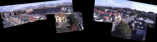
Above is an east-west partial panorama constructed from some of the Libraries' photographs.
To the extreme Left is the corner of Cambridge Terrace and Hereford Street, with the 1908 YMCA building on the site. Next to it (along Cambridge Terrace) can be seen the rear of the YMCA's Gordon Hall of 1885. To the Right of the Gordon Hall is a pale green two storey wooden building. Demolished in 1998, this was the 1940 headquarters of the NZ Army's Southern Military District. Clearly visible is the fire damaged roof of this building, which burnt in February, 1961.
Demolished in 1968, the 1908 YMCA building was replaced by the current Police Station in 1973. Along the range from Cambridge Terrace to Montreal Streets are the buildings of the 1863 Police Barracks and the 1873 & 1906 Police Stations. These were progressively demolished between 1973 and 1984 for a car park. At the corner of Montreal Street is the 1909 residence of the Chief Inspector of Police.
Between Montreal Street and Rolleston Avenue is a range of houses dating from circa 1880-1900. The most conspicuous of these is the vastly expanded Hereford Private Hotel ($10 a night and $1.50 for breakfast in 1984).
To the Right are the buildings of Canterbury University (now the Arts Centre). In the foreground can be seen the former 1883 Llanmaes House, subsequently the Student Union building from 1929, it is now the Dux de Lux Restaurant & Bar.
May 4, 2008
Canterbury Maps
Akaroa Harbour, Surveyed by Commander Owen Stanley (1811 – 1850) and James S. Hill of HMS Britomart, 1840
Map of the land sold by the tribe of the Ngaitahu to William Wakefield for the New Zealand Company, done at Akaroa on the 12th day of June 1848
Akaroa Harbour, surveyed by Captain J. L. Stokes, etc. H.M.S. Acheron, 1849-50
Birds eye view of proposed Christchurch Canal, 1906
Canterbury Land District. No. 6 plan shewing pastoral runs in Canterbury N.Z., 1889
Chart of Banks' Peninsula, taken by the officers of the Corvette Le Rhin, in 1844 & 1845
Christchurch area, 1963, showing swamps & vegetation cover. Compiled from Black Maps of 1856
County of Waimairi, District Scheme. Planning maps, 1974, Part 1
County of Waimairi, District Scheme. Planning maps, 1974, Part 2
County of Waimairi, District Scheme. Planning maps, 1974, Part 3
County of Waimairi, District Scheme. Planning maps, 1974, Part 4
County of Waimairi, District Scheme. Planning maps, 1974, Part 5
Extract from the French Government chart of Banks' Peninsula, 1845
Maori reserve north of Kaiapoi, circa 1850
Map of Banks' Peninsula showing roads and physical features, circa 1924
Stone's Map of Christchurch, circa 1930
Map of Christchurch, Supplement to The Press newspaper, circa 1930
Map of Christchurch, supplement to The Press, July 11th, 1912
Christchurch and suburbs, includes advertising at top and bottom of the map, 1922
Map of Province of Canterbury, by Thomas Cass (1817-1895), 1866
Map of surveyed districts, Canterbury, 1852. Part 2
Map of surveyed districts, Canterbury, 1852. Part 3
Map of surveyed districts, Canterbury, 1852. Part 4
Map of surveyed districts, Canterbury, 1852. Part 5
Map of surveyed districts, Canterbury, 1852. Part 6
Map of surveyed districts, Canterbury, 1852. Part 7
Map of the city of Christchurch, 1929. Part 1
Map of the city of Christchurch, 1929. Part 2
Map of the city of Christchurch, 1929. Part 3
Map of the city of Christchurch, 1929. Part 5
Map of the city of Christchurch, 1929. Part 6
Map of the city of Christchurch, 1929. Part 7
Map of the city of Christchurch, 1929. Part 8
Map of the city of Christchurch, 1929. Part 9
Map of the colony of New Zealand from official documents, 1844
Map of the Cust Road District, 1866
Map of the Heathcote Road district, 1879
Map of the Mandeville and Rangiora Road District, circa 1880
Map of the Mount Cook Road District, 1878
Map of the Oxford Road District, 1883
Map of the Port Hills' Akaroa Summit Road and reserves, circa 1918
Map of the Province of Canterbury, New Zealand shewing the pasturage runs, circa 1860
Map of the Riccarton Road District, 1879
New Brighton, Christchurch, building allotments, 1899
Map of the North and Middle Islands, General Survey Office, 1889
New Zealand : Te Anau Lake to Milford Sound : tourist foot road, 1904
New Zealand : the Southern Alps : Eastern slope of Mount Cook, 1904
Part of city of Christchurch, 1926
Parts of Canterbury and Nelson, shewing the route to Hanmer hot springs, 1900
Plan of a portion of the plains of Canterbury, 1865
Plan of Christchurch and suburbs, 1879
Plan of sections in blocks I and II, Lyndon Survey District, Hanmer Plains 1899
Plan of subdivision of rural sections no. 217 and 218, circa 1903
Plan of the city of Christchurch, 1874
Plan of the city of Christchurch (Selwyn County) Canterbury, N.Z., 1883
Plan of the Lowry Peak Run, in the Amuri District, province of Nelson, circa 1854
Plan of the town of Akaroa, 1878
Plan of the town of Ashburton, 1879
Upper Waimakariri and Lake Coleridge Road Districts, circa 1880
Plan of town of Ashbourne, circa 1883
Road map of the province of Canterbury, New Zealand, circa 1910
Sketch map shewing railways, South Island, 1887
Sketch of Middle Island (New Zealand) shewing the East Coast as laid down by Captain Stokes, 1850
Sketch of the harbours of Port Cooper and Port Levy November, 1842
South Westland and central portion of Southern Alps, New Zealand, circa 1900
Taununu's Pa, Ripapa Island, Lyttelton Harbour, 1872
The central portion of the Southern Alps of New Zealand, 1892
The colony of New Zealand, between 1887 and 1889
The Islands of New Zealand, 1838
The provinces of Canterbury and Westland, New Zealand during the great glacier period, circa 1875
Topographical map of Fox and Franz Josef glaciers, Westland, New Zealand, 1911
Township of Ashburton, between 1874 and 1880
Trigonometrical and topographical survey of the districts of Mandeville and Christchurch, 1850
Feb 12, 2008
The Canterbury Heritage Photographic Archive
Approximately 1,470 historically significant photographs are restored and added to the archive each year. The next update will be 31 March 2008.