Showing posts with label C-081-003/009. Show all posts

Jul 21, 2009

Mountfort's 1863 Sketches of the 1850 Land Office

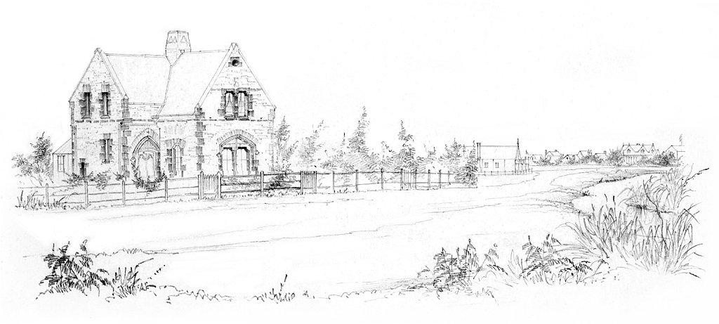
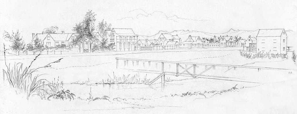
These are details from circa 1863 unfinished sketches, showing two views of the Canterbury Association's 1850 Land Office on the north-west corner of Oxford Terrace and Worcester Street. Adjoining Oxford Terrace on an east-west axis is the 1858 wing added to house the Magistrate's Court.


In the upper southerly view can be seen Davis's Hotel on the diagonally opposite corner, which began life as the 1851 home of the first Commissioner of Crown Lands and went on to eventually become the Clarendon Hotel. The lower northerly view shows the Canterbury Provincial Council buildings prior to the construction of the 1865 stone debating chamber.


The progressively enlarged Land Office became the first premises of the Christchurch City Council in 1864. Constructed of imported Australian Hardwoods, the province's first municipal building was demolished before March 1886 to make way for the extant Municipal Chambers, which can be seen to the centre foreground in the upper, and to the Right in the lower, of the following photographs.


Attributed by us to Christchurch's pre-eminent Gothic revival architect Benjamin Mountfort (1825-1898), and probably intended as preparatory to watercolour paintings, the original pencil sketches can be dated as being after 1861, as in full they show Mountfort's belfy for the St. Michael and All Angels church on Oxford Terrace.


The incorrectly identified Alexander Turnbull Library references:
Artist unknown: Flax & Maori heads, toe toe, &c; flax, tutu, fern, &c [ca 1872-1874?]
Reference number: C-081-009
1 drawing(s). Pencil drawing, 265 x 657 mm.. Horizontal image.
Part of Artist unknown :[Eight pencil sketches of Christchurch buildings and the Avon River. 1870-1875?] (C-081-003/009)
Drawings and Prints Collection, :
Scope and contents: Shows a section of the Avon River with several flax bushes in the foreground, and a flat bridge at the right. There are several house at the centre and left, and St Michael and All Angels Church (built 1872) is in the centre background, with the Port Hills of Christchurch in the distance.

Artist unknown :[Provincial Council Chambers, Christchurch. 1870-1875?]
Reference number: C-081-003
1 drawing(s). Pencil drawing, 240 x 410 mm.. Horizontal image.
Part of Artist unknown :[Eight pencil sketches of Christchurch buildings and the Avon River. 1870-1875?] (C-081-003/009)
Drawings and Prints Collection, :
Scope and contents: Shows the Provincial Council Chambers in the distance, seen past a house with a verandah at the left, and a fenced area of trees at the right.

Jul 19, 2009

Spirit of Place: Christchurch 1862


1,792 x 768 PIXEL IMAGE OPENS IN A NEW TAB OR WINDOW

It is probable that this simple pencil sketch, the significance of which has long been forgotten, would have struck a deeply meaningful chord amongst our earliest pioneers. Indicating the extant of development a decade after those first settlers landed at this very place, it had been their first view of the swampy plain on which they would build a city.

This a restoration of a panoramic westerly view of the northern half of the city of Christchurch, in late 1861 or early 1862. The artist's vantage point is at the junction of Oxford Terrace and Kilmore Street, to the immediate west of the 1850 Bricks Wharf, which is just out of view to the Right. Here those pioneers arrived from Lyttelton, with their tents, heavy luggage and kitset houses and when the first land sales began on the 16th of April, 1851, this immediate vicinity was the most sought after.

Below top: The artist's position was near to the 1926 Bricks Wharf monument, seen in this 1935 photograph, with the Manchester Street Bridge in the distance. Below bottom: the site is approximately opposite where the Central Fire Station is now situated.

Attributed by us to the renowned architect Benjamin Mountfort (1825-1898), and probably intended as preparatory to a watercolur painting, the pencil sketch can be dated by, among other considerations, the absence of the first Oxford Hotel on the north-east corner of Chester Street East (now part of Oxford Terrace) and Colombo Street. Mountfort lived not far from this vantage point in Gloucester Street from 1860.

Above: to the near Left of the drawing, at what is now the south-west corner of Madras Street and Oxford Terrace is The Hollies, built in 1861 to Mountfort's Gothic design for the eccentric Christ's College Maths Master Christopher Calvert, it was the city's first stone house.

The central part of the panorama includes all of the buildings surrounding Market Place (now Victoria Square).

They are situated along Armagh, Colombo and Durham Streets (above), Chester Street, lower Whatley Road (now Victoria Street) and Cambridge Terrace, where the Town Hall is now sited (below). All of the accurately depicted buildings are identifiable from early photographs.

Below: to the far Right can be seen the 1860 Anglican Chapel of Ease of St Luke the Evangelist at the north-east corner of Kilmore and Manchester Streets. Another aisle was added in 1864, with a tower and spire built a decade later. Now known as St Luke's in the City, the slate roofed wooden church was rebuilt in stone in 1908.
By the time that this view was drawn the Utopian dream had succumbed to utilitarian pragmatism, the population was approaching 2,000, a telegraph line connected the city with its port, Kerosene lamps had been installed as street lighting and the old wharf was still in regular use by small steamers.

But six years later the Waimakariri River would reclaim its flood plain and the Avon rose to the limits of its upper banks as seen in the foregound of the drawing (below). Major civil engineering work ensued and in 1871 the original land contours in this vicinity disappeared beneath a gravelled Oxford Terrace.


The Alexander Turnbull Library reference:
Artist unknown :[Avon River, Provincial Court buildings and houses, Christchurch. 1870-1875?]
Reference number: C-081-006
1 drawing(s). Pencil drawing, 249 x 535 mm.. Horizontal image.
Part of Artist unknown :[Eight pencil sketches of Christchurch buildings and the Avon River. 1870-1875?] (C-081-003/009)
Drawings and Prints Collection.

Jul 13, 2009

Chancery Lane 1862


LARGE IMAGE OPENS IN A NEW TAB OR WINDOW

This is an extensive reconstruction of a circa 1862 pencil sketch of three buildings on the southern side of Gloucester Street West at the location where Chancery Lane has been situated since 1882. The depiction of the side wall of the building to the Left remains in its original state to indicate the condition of the poorly conserved original. Below is the same location, opposite the Christchurch Central Library, as it appears in 2009.


Situated on Town Sections leased from the Revered James Wilson (1831-1886), Archdeacon of Akaroa, are the homes and business premises of three families, whose fathers would rise to prominence in the city and sire 25 children between them. Statistical extrapolation would suggest that by 2009 they would have about 18,000 living descendants.


It's possible to date the drawing to between 1861 and 1863 consequential to the two photographs above. The earlier image indicates that the buildings at each side of the drawing were still single-storey structures and that the central building was yet to be fitted with its glazed veranda.


At the Left of the partially completed drawing, which is annotated with "extend on both sides," is the two-storey premises of the painter, paperhanger and glazier William Epthorp Samuels (1833-1917). His wife Eliza would bear a son and ten daughters.

Arriving from Sydney in 1859, Bill Samuels would be one of the founders of the Christchurch Fire Brigade in the following year. By 1864 he is recorded as the Publican of the White Swan Hotel on the southwest corner of Tuam and Montreal Streets. By the late 1860s the Samuels had moved to Thames, where Bill is recorded as a bankrupt hotel keeper in 1870.

The family returned to Christchurch after six years in the Goldfields district and by the 1880s Samuels is recorded as having achieved some prominence in the United Ancient Order of Druids. In 1891 his occupation was stated as Artist. A Justice of the Peace and Christchurch City Councillor from 1894 to 1905, Samuels lived to the age of 84 and is buried in the Barbadoes Street Cemetery


Elizabeth and John Coe (1832-1893) had established themselves at Lyttelton by 1855. John operated a liverly stables next door to the Mitre Hotel in Canterbury Street and, adjacent to the stables, Elizabeth opened a Millinery shop, with their accommodation above. Also a provincial government contractor, John established the first coach service from Christchurch to Lyttelton. By 1857 Christchurch had begun to rival its Port in size, the writing was on the wall as far as commercial development was concerned, and in 1859 the Coes moved to the new city.


With the architect Isaac Luck (1817-1881) favouring the the Tudoresque style of architecture and his partner Benjamin Mountfort (1825-1898) tending to the Gothic alternative, Elizabeth Coe's 1859 Millinery Establishment (above) at the centre of the drawing is probably to the design of the latter. The subject matter, artistic style, architectural accuracy of the buildings and the hand written annotations on the drawing would tend to support an hypothesis that it could be an unattributed sketch by Mountfort.

The Coes prospered to the extent that in 1866 John was able to purchase 1,640 acres at Irwell in the Ellesmere district to the near south of Christchurch. Here they built Bruscoe Lodge, a two-storey home with sixteen rooms. One of their many grandaughters married the renowned artist Sydney Lough Thompson (1877-1973), and a direct descendant is Mayor of the Selwyn district in 2009. Probably familiar to most Canterbrians is Coes Ford, a popular recreational reserve near Irwell that takes its name from these early settlers in the district.


To the Right of the drawing is the 1858 home of Sarah Elizabeth and Joseph William Papprill (1801-1880), who had come to Christchurch in 1856. By 1864 the building had acquired a second storey to accomodate the first seven of their eventual nine children. A Tailor and Habit maker by trade, Papprill sold the Gloucester Street business in 1873 to an employee and was describing himself as a Gentleman by the following year.

Joseph lived to the age of 79 and is buried in the Barbadoes Street Cemetery. His eldest son entered the legal profession and a grandson succeeded to the Practice, which continues to prosper in 2009 as Papprill Hadfield & Aldous.


The renowned doctor and pioneer photographer Alfred Charles Barker (1819-1873) reminisced that the alley way between Elizabeth Coe's Millinery and Joseph Papprill's Tailor's shop had been a popular short cut for revellers in the 1860s, who disturbed his evening tranquility.


By 1881 the last of the Venerable Archdeacon's 21 year leases expired and the structures depicted in the drawing were demolished to make way for a matching pair of buildings on either side of the Alley (above). which became officially known as Chancery Lane. The last surving remnant of these is the eastern third of the building to the Right of the Lane (below).


Addendum

Chancery Lane 1960


The Alexander Turnbull Library reference:
Artist unknown :[Three shops in Gloucester Street, Christchurch. 1870s]
Reference number: C-081-004-2
1 drawing(s). Pencil drawing on sheet, 240 x 535 mm.. Horizontal image.
Part of Artist unknown :[Eight pencil sketches of Christchurch buildings and the Avon River. 1870-1875?] (C-081-003/009)
Part of Artist unknown :[Two Christchurch sketches; Slate roofed stone house; and, Three shops in Gloucester Street. 1860-1870s] (C-081-004)
Drawings and Prints Collection, :
Scope and contents

Notes

Shows three businesses, probably in Gloucester Street, Christchurch: a painter's and glazier's business; Albion House Millinery; and [T] Papp[rill tailors].

Location Gloucester Street assumed from the fact that T Papprill, tailor is listed as being in Gloucester Street in Wises Directory for 1872.

Jul 9, 2009

The Hollies, Oxford Terrace, Christchurch, 1864


LARGE IMAGE OPENS IN A NEW TAB OR WINDOW

Viewed from near the Madras Street bridge, this is a westerly view of Oxford Terrace in about 1864.

This is a restoration of one of a series of eight pencil sketches by the same unidentified artist. The subject matter, artistic style, architectural accuracy of the buildings and the graphological evaluation of the hand written annotations would tend to support an hypothesis that they could be the unattributed work of Benjamin Woolfield Mountfort (1825-1898).


Above is the location as seen in 2009, the yellow arrow in the lower image indicates the position and aspect of the artist.

To the Left, at the corner of Madras Street is The Hollies, built in 1861 to the design of Benjamin Mountfort, it was the city's first stone house.


The home of the eccentric Christopher Alderson Calvert (1811-1883), initially a Maths teacher at Christ’s College and then Registrar of the Supreme Court, a prominent feature of the dwelling was the Gothic arched entrance, with the arms of the Calvert family carved in stone above the door.

Originally sited on nearly two hectares, half the garden had already been sold off by the time that the grocer Percival Pearce purchased the house in a Mortgagee's sale in 1871. Opened as the The Hollies Store, the pretentous coat of arms and Gothic entrance succumbed to the renovation as a Grocer's shop.


The last owner was the tobacconist Hyman Marks, who initially let the former house, subsequently demolishing it in 1881. Two substantial wooden two-storey houses were built on the site. These in turn were replaced in 1962 by the high-rise offices of the Lyttelton Harbour Board, the building becoming the Poplars Apartment Hotel in 1997 (above).

Below: in the middle distance, just Right of centre, is the 1859 Court Star of Canterbury Lodge of the Ancient Order of Foresters. Much altered over time, the building survived for more than 140 years to be replaced by an office block, the ground floor of which is currently occupied by the popular Bohemian Cafe and Bar.


Below: to the Right, in the far distance, can bee seen the backs of the commercial buildings on the eastern side of Colombo Street, facing on to Market Place (now Victoria Square). The most prominent is the gabled store and real estate agency of Herbert Edward Alport (1820-1886) and at the far Right is a flag flying above the 1857 Post Office. It is the configuration of these buidlings that helps to date the sketch to after 1861, but before 1865.


The Alexander Turnbull Library reference:
Artist unknown :[Slate roofed stone house. 1870s]
Reference number: C-081-004-1
1 drawing(s). Pencil drawing on sheet, 240 x 535 mm.. Horizontal image.
Part of Artist unknown :[Eight pencil sketches of Christchurch buildings and the Avon River. 1870-1875?] (C-081-003/009)
Part of Artist unknown :[Two Christchurch sketches; Slate roofed stone house; and, Three shops in Gloucester Street. 1860-1870s] (C-081-004)
Drawings and Prints Collection

Jul 8, 2009

Christchurch 1864: Oxford Terrace Streetscape Identified


Viewed from Cambridge Terrace, this is an extensive restoration of a remarkably accurate 1864 pencil sketch of Oxford Terrace between Worcester, Hereford and Cashel Streets. Below it is a similar view as it appears in 2009.

Lurking in the on-line archive of the Alexander Turnbull Library, it's described as "Bridge and houses, Avon River, Christchurch. 1870-1875?" By an unknown artist, the original is extensively annotated, probably indicating that it was intended to be a preliminary sketch for a painting.

This is one of a series of eight pencil sketches by the same unidentified artist. The subject matter, artistic style, architectural accuracy of the buildings and the graphological evaluation of the hand written annotations would tend to support an hypothesis that they could be the unattributed work of Benjamin Woolfield Mountfort (1825-1898).


To the foreground is the Worcester Street footbridge. Constructed in February, 1851, it was replaced in 1864 by a wider bridge for wheeled traffic.


To the far Left is the 1851 house of William Guise Brittan (1807–76), the Commissioner of Crown Lands. First premises in which the provincial government met, by the time of the sketch it formed the earliest part of Davis's Hotel. It would be much enlarged after 1864, the year after Rowland Robert Teape Davis (1807-1879) sold out to George Oram (1826-1876) and moved to Heathcote.


Davis's hostelry was renamed as the Lyttelton Hotel, when the above 1858 extension was built. Eventually joined to the former Brittan house by a substantial wing, the hotel was renamed as the Clarendon in 1868. Progressively demolished in 1903-4 it was replaced by a stone building, the facade of which survives below the 1987 Clarendon Tower. The height of the nearby tree and the residential development along Oxford Terrace towards Cashel Street confirm the ascribed date.


At the norther corner of Hereford Street is a commercial building, the earliest origins of which are yet to be ascertained. Occupied by many tenants, it's recorded as being the premises of a Fishmonger, Cabinetmaker, Tailor and Taxidermist at various times.


In Hereford Street can be seen the circa 1859 two storey townhouse of Riccarton farmer John Shand (1805-1874), Subsequently Solicitor's offices and now known as Shand's Emporium, it's the only building in the sketch to have survived.


On the southern corner of Hereford Street and Oxford Terrace is the August 1854 offices of Joseph Brittan's Canterbury Standard newspaper. The city's first evening paper, it ceased publication in 1860. Subsequently the Standard Hotel, the building was moved to Bealey Avenue in 1868.


Granted a 30 year lease in 1858 on what is still known as Mill Island is David Inwood's water-wheel powered grain Mill. A night shelter for the city's homeless from 1889, it was demolished in 1897.


The Alexander Turnbull Library reference:
Artist unknown :[Bridge and houses, Avon River, Christchurch. 1870-1875?]
Reference number: C-081-005
1 drawing(s). Pencil drawing, 240 x 410 mm.. Horizontal image.
Part of Artist unknown :[Eight pencil sketches of Christchurch buildings and the Avon River. 1870-1875?] (C-081-003/009)
Drawings and Prints Collection