LARGE IMAGE OPENS IN A NEW TAB OR WINDOW
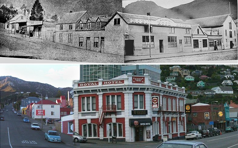
This is an extensive reconstruction of a circa 1862 pencil sketch of three buildings on the southern side of Gloucester Street West at the location where Chancery Lane has been situated since 1882. The depiction of the side wall of the building to the Left remains in its original state to indicate the condition of the poorly conserved original. Below is the same location, opposite the Christchurch Central Library, as it appears in 2009.

Situated on Town Sections leased from the Revered James Wilson (1831-1886), Archdeacon of Akaroa, are the homes and business premises of three families, whose fathers would rise to prominence in the city and sire 25 children between them. Statistical extrapolation would suggest that by 2009 they would have about 18,000 living descendants.

It's possible to date the drawing to between 1861 and 1863 consequential to the two photographs above. The earlier image indicates that the buildings at each side of the drawing were still single-storey structures and that the central building was yet to be fitted with its glazed veranda.
At the Left of the partially completed drawing, which is annotated with "extend on both sides," is the two-storey premises of the painter, paperhanger and glazier William Epthorp Samuels (1833-1917). His wife Eliza would bear a son and ten daughters.
Situated on Town Sections leased from the Revered James Wilson (1831-1886), Archdeacon of Akaroa, are the homes and business premises of three families, whose fathers would rise to prominence in the city and sire 25 children between them. Statistical extrapolation would suggest that by 2009 they would have about 18,000 living descendants.
It's possible to date the drawing to between 1861 and 1863 consequential to the two photographs above. The earlier image indicates that the buildings at each side of the drawing were still single-storey structures and that the central building was yet to be fitted with its glazed veranda.

At the Left of the partially completed drawing, which is annotated with "extend on both sides," is the two-storey premises of the painter, paperhanger and glazier William Epthorp Samuels (1833-1917). His wife Eliza would bear a son and ten daughters.
Arriving from Sydney in 1859, Bill Samuels would be one of the founders of the Christchurch Fire Brigade in the following year. By 1864 he is recorded as the Publican of the White Swan Hotel on the southwest corner of Tuam and Montreal Streets. By the late 1860s the Samuels had moved to Thames, where Bill is recorded as a bankrupt hotel keeper in 1870.
The family returned to Christchurch after six years in the Goldfields district and by the 1880s Samuels is recorded as having achieved some prominence in the United Ancient Order of Druids. In 1891 his occupation was stated as Artist. A Justice of the Peace and Christchurch City Councillor from 1894 to 1905, Samuels lived to the age of 84 and is buried in the Barbadoes Street Cemetery
Elizabeth and John Coe (1832-1893) had established themselves at Lyttelton by 1855. John operated a liverly stables next door to the Mitre Hotel in Canterbury Street and, adjacent to the stables, Elizabeth opened a Millinery shop, with their accommodation above. Also a provincial government contractor, John established the first coach service from Christchurch to Lyttelton. By 1857 Christchurch had begun to rival its Port in size, the writing was on the wall as far as commercial development was concerned, and in 1859 the Coes moved to the new city.

With the architect Isaac Luck (1817-1881) favouring the the Tudoresque style of architecture and his partner Benjamin Mountfort (1825-1898) tending to the Gothic alternative, Elizabeth Coe's 1859 Millinery Establishment (above) at the centre of the drawing is probably to the design of the latter. The subject matter, artistic style, architectural accuracy of the buildings and the hand written annotations on the drawing would tend to support an hypothesis that it could be an unattributed sketch by Mountfort.
The Coes prospered to the extent that in 1866 John was able to purchase 1,640 acres at Irwell in the Ellesmere district to the near south of Christchurch. Here they built Bruscoe Lodge, a two-storey home with sixteen rooms. One of their many grandaughters married the renowned artist Sydney Lough Thompson (1877-1973), and a direct descendant is Mayor of the Selwyn district in 2009. Probably familiar to most Canterbrians is Coes Ford, a popular recreational reserve near Irwell that takes its name from these early settlers in the district.
To the Right of the drawing is the 1858 home of Sarah Elizabeth and Joseph William Papprill (1801-1880), who had come to Christchurch in 1856. By 1864 the building had acquired a second storey to accomodate the first seven of their eventual nine children. A Tailor and Habit maker by trade, Papprill sold the Gloucester Street business in 1873 to an employee and was describing himself as a Gentleman by the following year.
Elizabeth and John Coe (1832-1893) had established themselves at Lyttelton by 1855. John operated a liverly stables next door to the Mitre Hotel in Canterbury Street and, adjacent to the stables, Elizabeth opened a Millinery shop, with their accommodation above. Also a provincial government contractor, John established the first coach service from Christchurch to Lyttelton. By 1857 Christchurch had begun to rival its Port in size, the writing was on the wall as far as commercial development was concerned, and in 1859 the Coes moved to the new city.
With the architect Isaac Luck (1817-1881) favouring the the Tudoresque style of architecture and his partner Benjamin Mountfort (1825-1898) tending to the Gothic alternative, Elizabeth Coe's 1859 Millinery Establishment (above) at the centre of the drawing is probably to the design of the latter. The subject matter, artistic style, architectural accuracy of the buildings and the hand written annotations on the drawing would tend to support an hypothesis that it could be an unattributed sketch by Mountfort.
The Coes prospered to the extent that in 1866 John was able to purchase 1,640 acres at Irwell in the Ellesmere district to the near south of Christchurch. Here they built Bruscoe Lodge, a two-storey home with sixteen rooms. One of their many grandaughters married the renowned artist Sydney Lough Thompson (1877-1973), and a direct descendant is Mayor of the Selwyn district in 2009. Probably familiar to most Canterbrians is Coes Ford, a popular recreational reserve near Irwell that takes its name from these early settlers in the district.

To the Right of the drawing is the 1858 home of Sarah Elizabeth and Joseph William Papprill (1801-1880), who had come to Christchurch in 1856. By 1864 the building had acquired a second storey to accomodate the first seven of their eventual nine children. A Tailor and Habit maker by trade, Papprill sold the Gloucester Street business in 1873 to an employee and was describing himself as a Gentleman by the following year.
Joseph lived to the age of 79 and is buried in the Barbadoes Street Cemetery. His eldest son entered the legal profession and a grandson succeeded to the Practice, which continues to prosper in 2009 as Papprill Hadfield & Aldous.
The renowned doctor and pioneer photographer Alfred Charles Barker (1819-1873) reminisced that the alley way between Elizabeth Coe's Millinery and Joseph Papprill's Tailor's shop had been a popular short cut for revellers in the 1860s, who disturbed his evening tranquility.

By 1881 the last of the Venerable Archdeacon's 21 year leases expired and the structures depicted in the drawing were demolished to make way for a matching pair of buildings on either side of the Alley (above). which became officially known as Chancery Lane. The last surving remnant of these is the eastern third of the building to the Right of the Lane (below).

Addendum
The renowned doctor and pioneer photographer Alfred Charles Barker (1819-1873) reminisced that the alley way between Elizabeth Coe's Millinery and Joseph Papprill's Tailor's shop had been a popular short cut for revellers in the 1860s, who disturbed his evening tranquility.
By 1881 the last of the Venerable Archdeacon's 21 year leases expired and the structures depicted in the drawing were demolished to make way for a matching pair of buildings on either side of the Alley (above). which became officially known as Chancery Lane. The last surving remnant of these is the eastern third of the building to the Right of the Lane (below).
Addendum

Chancery Lane 1960
The Alexander Turnbull Library reference:
Artist unknown :[Three shops in Gloucester Street, Christchurch. 1870s]
Reference number: C-081-004-2
1 drawing(s). Pencil drawing on sheet, 240 x 535 mm.. Horizontal image.
Part of Artist unknown :[Eight pencil sketches of Christchurch buildings and the Avon River. 1870-1875?] (C-081-003/009)
Part of Artist unknown :[Two Christchurch sketches; Slate roofed stone house; and, Three shops in Gloucester Street. 1860-1870s] (C-081-004)
Drawings and Prints Collection, :
Scope and contents
Notes
Shows three businesses, probably in Gloucester Street, Christchurch: a painter's and glazier's business; Albion House Millinery; and [T] Papp[rill tailors].
Location Gloucester Street assumed from the fact that T Papprill, tailor is listed as being in Gloucester Street in Wises Directory for 1872.