Showing posts with label house. Show all posts

Jul 19, 2009

Spirit of Place: Christchurch 1862


1,792 x 768 PIXEL IMAGE OPENS IN A NEW TAB OR WINDOW

It is probable that this simple pencil sketch, the significance of which has long been forgotten, would have struck a deeply meaningful chord amongst our earliest pioneers. Indicating the extant of development a decade after those first settlers landed at this very place, it had been their first view of the swampy plain on which they would build a city.

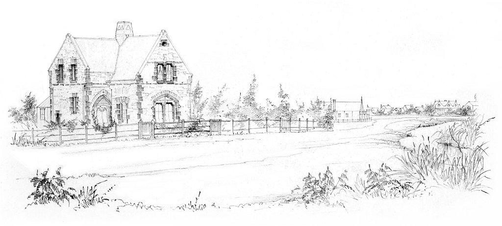
This a restoration of a panoramic westerly view of the northern half of the city of Christchurch, in late 1861 or early 1862. The artist's vantage point is at the junction of Oxford Terrace and Kilmore Street, to the immediate west of the 1850 Bricks Wharf, which is just out of view to the Right. Here those pioneers arrived from Lyttelton, with their tents, heavy luggage and kitset houses and when the first land sales began on the 16th of April, 1851, this immediate vicinity was the most sought after.

Below top: The artist's position was near to the 1926 Bricks Wharf monument, seen in this 1935 photograph, with the Manchester Street Bridge in the distance. Below bottom: the site is approximately opposite where the Central Fire Station is now situated.

Attributed by us to the renowned architect Benjamin Mountfort (1825-1898), and probably intended as preparatory to a watercolur painting, the pencil sketch can be dated by, among other considerations, the absence of the first Oxford Hotel on the north-east corner of Chester Street East (now part of Oxford Terrace) and Colombo Street. Mountfort lived not far from this vantage point in Gloucester Street from 1860.

Above: to the near Left of the drawing, at what is now the south-west corner of Madras Street and Oxford Terrace is The Hollies, built in 1861 to Mountfort's Gothic design for the eccentric Christ's College Maths Master Christopher Calvert, it was the city's first stone house.

The central part of the panorama includes all of the buildings surrounding Market Place (now Victoria Square).

They are situated along Armagh, Colombo and Durham Streets (above), Chester Street, lower Whatley Road (now Victoria Street) and Cambridge Terrace, where the Town Hall is now sited (below). All of the accurately depicted buildings are identifiable from early photographs.

Below: to the far Right can be seen the 1860 Anglican Chapel of Ease of St Luke the Evangelist at the north-east corner of Kilmore and Manchester Streets. Another aisle was added in 1864, with a tower and spire built a decade later. Now known as St Luke's in the City, the slate roofed wooden church was rebuilt in stone in 1908.
By the time that this view was drawn the Utopian dream had succumbed to utilitarian pragmatism, the population was approaching 2,000, a telegraph line connected the city with its port, Kerosene lamps had been installed as street lighting and the old wharf was still in regular use by small steamers.

But six years later the Waimakariri River would reclaim its flood plain and the Avon rose to the limits of its upper banks as seen in the foregound of the drawing (below). Major civil engineering work ensued and in 1871 the original land contours in this vicinity disappeared beneath a gravelled Oxford Terrace.


The Alexander Turnbull Library reference:
Artist unknown :[Avon River, Provincial Court buildings and houses, Christchurch. 1870-1875?]
Reference number: C-081-006
1 drawing(s). Pencil drawing, 249 x 535 mm.. Horizontal image.
Part of Artist unknown :[Eight pencil sketches of Christchurch buildings and the Avon River. 1870-1875?] (C-081-003/009)
Drawings and Prints Collection.

Jul 15, 2009

The Oldest Building in Canterbury


Richard Pollard's 1840 cottage photographed on its Cathedral Square site in 1862

Built in 1840 of Black Pine and Totara in Hagley Park (the site is indicated below by a yellow square), the Surveyor's cottage was relocated to the vicinity of Press Lane at Cathedral Square in 1852. By 1900 it had been moved again to the southern side of Moorhouse Avenue, near to the eastern corner of Grove Road. The cottage's subsequent fate is yet to be ascertained.


Here follows three articles from The Star newspaper relating to the early history of the cottage.

The Oldest Building in Canterbury - The Star, 12 September 1900

To settle what seems to be a somewhat vexed question, a representative of the Lyttelton Times yesterday made inquiries among a number of the Pilgrims with regard to the authenticity, or otherwise, of the statement that the building now being used as a residence on the South Belt, near the Southern Cross Hotel, was the earliest of the dwellings occupied by the dwellers on the plains.

The representative interviewed many persons, and, towards evening, met Mr Edmund Smart, who resides at 55 Cashel Street, Linwood, and who kindly gave him the particulars he was seeking. Mr Smart is the eldest son of a family of ten, who arrived with their parents (long since dead) in the ship Randolph, on December the 16th, 1850. Their father had been engaged in England as a farm servamt, but on arrival here found that no such employment was available. He and his family therefore entered into what occupations they could find. Edmund became an employee of Mr William Todd, a carrier and contractor, and carted the first half-ton of coal used by the late Mr John Anderson in his smithy in Cashel Street (now well known as the Canterbury Foundry), from the Christchurch Wharf at Woolston, to its destination. It may be mentioned that the half-ton cost Mr Anderson £4 10 shillings, and the carriage 12 shillings.

While engaged by Mr Todd, Mr Smart assisted in the removal of a building from Hagley Park into Christchuroh, and that building, it is claimed, has the honour of being the oldest of the buildings still standing, in the province of Canterbury.

It was a two-roomed dwelling-place, and was built in 1840 for Mr Pollard, who was engaged in surveying under the New Zealand Government, and who had taken up his quarters in Hagley Park on account of its proximity to what everyone then thought must in time become a centre of population.

From this hut, or shanty, all exploring parties started, and to it all returned. The timbers of which it was constructed had been cut from the Riccarton bush, now known as Deans', and consisted of black pine and totara. There was plenty of it available as Bob Kerr and Harry Royal, two runaway sailors, had occupied their spare time in cutting out the best timber they could lay their hands on without much trouble, till it became a drug on the market.

Mr Smart, when he arrived in 1850, and became attached to the contracting staff of Mr Todd, had, in the course of a year or so, to remove this building from its site in Hagley Park, just above the Townsend Falls, to a place where it was of more use.

Dr Chapman had by that time installed himself in practice in Christchurch, and, having purchased this two-roomed building, agreed with Mr Todd to remove it into a central position. This was done, E. Smart, J. Sales and W. Prebble assisting, and for some years it stood at the back of the old Gaiety Theatre, where it was used as a laundry for Warner's Hotel, and it is stated that the timbers in it were in as good, if not a better, condition than that of many buildings of a much more recent date.

It is known that Mr. Pollard was here in 1840, and that, before making a start on his survey, he fixed his headquarters in Hagley Park, and it was in 1852 that Mr Smart, in the employ of Mr Todd, assisted in the removal of the building and saw it re-erected for Dr Chapman, so that fully, ten years must have elapsed between the erection of this building and of the one imported and erected by the late Mr George Gould in Armagh Street.


MORE HISTORICAL RECOLLECTIONS - The Star, 18 September 1900

Mr Edmund Smart, whose remarks have given rise to the discussion, on the question, of which is the oldest building in Canterbury, has been for several days invalided through an attack of blood poisoning. He has read with a good deal of interest the remarks of Mrs Deans and those appearing above the initials of "G. J. B." Neither of these, however, shake his opinion that Mr Pollard's two-roomed shanty, which he and others removad from Hagley Park in 1852, to the order of Dr Chapman, is the very first of all buildings erected in Canterbury now in existence.

It is urged that Mrs Deans herself admits that the first building erected on the Riccarton property was recently demolished, and that she will most be surprised to hear that a Mr Pollard, surveyor, worked on the Canterbury Plains as a surveyor in 1842.

It is further stated that when the Dean Brothers arrived, and made, their home at Riccarton, they saw little or nothing of him, as he was more frequently engaged in his professional work on the Peninsula, but that, all the same, he made his headquarters in Hagley Park, and, having done so, engaged Robert Kerr and Harry Royal to make his home there.

Mr C. Hood-Williams distinctly recollects the building occupied by Mr Pollard, but being then only a lad of seven years of age, he cannot, of course, say what the age of the building might be. He was in the habit of passing backwards am forwards on his way to Christ's College, where Mr. Williams was one of the first four pupils.

Mr Smart, however, contends that from the evidences of the state of the building when he, James Sales and William Prebble removed it to its central position near Cathedral Square, it must have been erected some ten or twelve years previously. It was during the month, of September, 1852, that the building was removed...


HISTORICAL SITES PEGGED IN HAGLEY PARK - The Star, 22 January 1906

Two old pioneers, who have grown grey-haired in the work of colonisation in Canterbury, accompanied Mr H. G. Ell and two reporters through Hagley Park this morning, and located interesting historical sites, and Mr Ell drove pegs into the ground so that the spots might be identified.

The pegs are marked with numbers, which will correspond with records, describing the incidents associated with them. The Hon C. C. Bowen, Speaker of the Legislative Council, and Mr C. Hood Williams, secretary to the Lyttelton Harbour Board, are the gentlemen who accompanied Mr Ell, and as the party strolled over the Park, which was an utter wilderness when they saw it first, over fifty years ago, they talked of times which have gone by.

The first peg was driven in on the site of the first bakery established in Christchurch. It was conducted by Mr Inwood, and the building was erected in January, 1851. The spot is on the bank of the Avon, as it sweeps round and runs close up to the Riccarton Road, which divides the North Park from the South Park, and the second site pegged off is where Mr Pollard's Raupo whare stood, about a hundred and fifty yards northward of the first peg...

Jul 13, 2009

The University of Canterbury's New School of Music


Designed by the beknighted Miles Warren, in what might appear to be a ponderous derivative of 1970s architectural style, is the proposed University of Canterbury's National Conservatorium of Music building.

The intended site is part of the renaissance medieval Gothic Arts Centre complex bounded by Worcester, Hereford, Montreal Streets and Rolleston Avenue.

Not previously built upon, it was originally the recreational ground of the 1881 Christchurch Boys' High School and a part of the rear garden of the 1883 Llanmaes House (much enlarged, the house became the University's Student Union building in 1929 and is now the Dux de Lux Restaurant & Bar).

The proposed site is to be seen below near the centre of this 1940 aerial photograph.


Below: in 1941 the Army erected a large radio aerial on the site, but other than that it's always been a recreational reserve, that is until the good burghers of Christchurch managed to turn it into yet another car park.


The predictable pre-construction media release advises us that the new building will be "in a style that complements existing buildings, none of which would be impacted by the new structure."

We beg to disagree; it could seem that the 80 year-old architect may be a little out of touch with more recent advances in architectural engineering. If the site must be built upon, and that's debatable, then perhaps something along the lines of this new building for the medieval centre of the Estonian city of Tallinn, might be more cost effective and inspiring.


In what might seem to be a conflict of interest, the venerable architect had more than a finger in the pie of his bronze likeness being erected in the grounds of the Arts Centre complex. Might we respectfully suggest that it could be time for him to consider bowing out gracefully in favour of a more imaginative architect among whose principal qualifications is not membership of our old-boy network.

Further reading:
Richard Sinke's extensively illustrated Save Our Arts Centre web site.

Arts Centre site 'only city option' The Press newspaper, 10 July, 2009.

The University of Canterbury's self-congratulatory new School of Music web site.
Photo credit: top image; detail from Wellington artist Ian Stantiall's perspective of the new School of Music building.

Jul 9, 2009

The Hollies, Oxford Terrace, Christchurch, 1864


LARGE IMAGE OPENS IN A NEW TAB OR WINDOW

Viewed from near the Madras Street bridge, this is a westerly view of Oxford Terrace in about 1864.

This is a restoration of one of a series of eight pencil sketches by the same unidentified artist. The subject matter, artistic style, architectural accuracy of the buildings and the graphological evaluation of the hand written annotations would tend to support an hypothesis that they could be the unattributed work of Benjamin Woolfield Mountfort (1825-1898).


Above is the location as seen in 2009, the yellow arrow in the lower image indicates the position and aspect of the artist.

To the Left, at the corner of Madras Street is The Hollies, built in 1861 to the design of Benjamin Mountfort, it was the city's first stone house.


The home of the eccentric Christopher Alderson Calvert (1811-1883), initially a Maths teacher at Christ’s College and then Registrar of the Supreme Court, a prominent feature of the dwelling was the Gothic arched entrance, with the arms of the Calvert family carved in stone above the door.

Originally sited on nearly two hectares, half the garden had already been sold off by the time that the grocer Percival Pearce purchased the house in a Mortgagee's sale in 1871. Opened as the The Hollies Store, the pretentous coat of arms and Gothic entrance succumbed to the renovation as a Grocer's shop.


The last owner was the tobacconist Hyman Marks, who initially let the former house, subsequently demolishing it in 1881. Two substantial wooden two-storey houses were built on the site. These in turn were replaced in 1962 by the high-rise offices of the Lyttelton Harbour Board, the building becoming the Poplars Apartment Hotel in 1997 (above).

Below: in the middle distance, just Right of centre, is the 1859 Court Star of Canterbury Lodge of the Ancient Order of Foresters. Much altered over time, the building survived for more than 140 years to be replaced by an office block, the ground floor of which is currently occupied by the popular Bohemian Cafe and Bar.


Below: to the Right, in the far distance, can bee seen the backs of the commercial buildings on the eastern side of Colombo Street, facing on to Market Place (now Victoria Square). The most prominent is the gabled store and real estate agency of Herbert Edward Alport (1820-1886) and at the far Right is a flag flying above the 1857 Post Office. It is the configuration of these buidlings that helps to date the sketch to after 1861, but before 1865.


The Alexander Turnbull Library reference:
Artist unknown :[Slate roofed stone house. 1870s]
Reference number: C-081-004-1
1 drawing(s). Pencil drawing on sheet, 240 x 535 mm.. Horizontal image.
Part of Artist unknown :[Eight pencil sketches of Christchurch buildings and the Avon River. 1870-1875?] (C-081-003/009)
Part of Artist unknown :[Two Christchurch sketches; Slate roofed stone house; and, Three shops in Gloucester Street. 1860-1870s] (C-081-004)
Drawings and Prints Collection

Jul 8, 2009

Christchurch 1864: Oxford Terrace Streetscape Identified


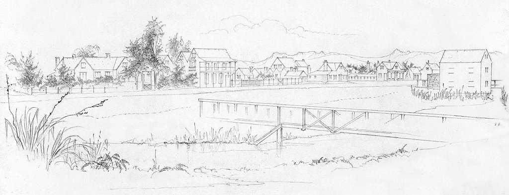
Viewed from Cambridge Terrace, this is an extensive restoration of a remarkably accurate 1864 pencil sketch of Oxford Terrace between Worcester, Hereford and Cashel Streets. Below it is a similar view as it appears in 2009.

Lurking in the on-line archive of the Alexander Turnbull Library, it's described as "Bridge and houses, Avon River, Christchurch. 1870-1875?" By an unknown artist, the original is extensively annotated, probably indicating that it was intended to be a preliminary sketch for a painting.

This is one of a series of eight pencil sketches by the same unidentified artist. The subject matter, artistic style, architectural accuracy of the buildings and the graphological evaluation of the hand written annotations would tend to support an hypothesis that they could be the unattributed work of Benjamin Woolfield Mountfort (1825-1898).


To the foreground is the Worcester Street footbridge. Constructed in February, 1851, it was replaced in 1864 by a wider bridge for wheeled traffic.


To the far Left is the 1851 house of William Guise Brittan (1807–76), the Commissioner of Crown Lands. First premises in which the provincial government met, by the time of the sketch it formed the earliest part of Davis's Hotel. It would be much enlarged after 1864, the year after Rowland Robert Teape Davis (1807-1879) sold out to George Oram (1826-1876) and moved to Heathcote.


Davis's hostelry was renamed as the Lyttelton Hotel, when the above 1858 extension was built. Eventually joined to the former Brittan house by a substantial wing, the hotel was renamed as the Clarendon in 1868. Progressively demolished in 1903-4 it was replaced by a stone building, the facade of which survives below the 1987 Clarendon Tower. The height of the nearby tree and the residential development along Oxford Terrace towards Cashel Street confirm the ascribed date.


At the norther corner of Hereford Street is a commercial building, the earliest origins of which are yet to be ascertained. Occupied by many tenants, it's recorded as being the premises of a Fishmonger, Cabinetmaker, Tailor and Taxidermist at various times.


In Hereford Street can be seen the circa 1859 two storey townhouse of Riccarton farmer John Shand (1805-1874), Subsequently Solicitor's offices and now known as Shand's Emporium, it's the only building in the sketch to have survived.


On the southern corner of Hereford Street and Oxford Terrace is the August 1854 offices of Joseph Brittan's Canterbury Standard newspaper. The city's first evening paper, it ceased publication in 1860. Subsequently the Standard Hotel, the building was moved to Bealey Avenue in 1868.


Granted a 30 year lease in 1858 on what is still known as Mill Island is David Inwood's water-wheel powered grain Mill. A night shelter for the city's homeless from 1889, it was demolished in 1897.


The Alexander Turnbull Library reference:
Artist unknown :[Bridge and houses, Avon River, Christchurch. 1870-1875?]
Reference number: C-081-005
1 drawing(s). Pencil drawing, 240 x 410 mm.. Horizontal image.
Part of Artist unknown :[Eight pencil sketches of Christchurch buildings and the Avon River. 1870-1875?] (C-081-003/009)
Drawings and Prints Collection

Jul 2, 2009

Christchurch Cob Cottages


LARGE IMAGE OPENS IN A NEW TAB OR WINDOW

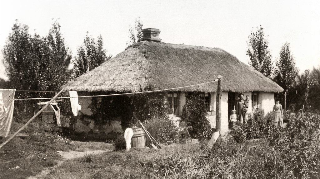
This is a restoration of a circa 1870 photograph of a family standing in front of their Cob or mud brick cottage.

This type of dwelling proliferated in the environs of Christchurch during the earliest period of settlement and were most common in the southern suburbs of Waltham, Sydenham and Addington, when that district was favoured as a location for market gardens.

Below is a circa 1880 photograph of a Cob cottage in Lincoln Road, Addington. The proportions, roof lines, chimney location and window frames indicate that it may be the same cottage as depicted above.


Only one of the city's original Cob cottages, dating from about 1860, is known to have survived. Pictured below a century ago, and then forty years later, it is situated near the southern end of the Ferry Road bridge at the estuary of the Heathcote River.


Nearby, in the Ferrymead Heritage Park, is a facsimile of an early Cob cottage (below). Sadly, it sports an inauthentic corrugated iron roof, a feature that doesn't enter the city's photographic record until 1879; a time when the surviving Cob cottages were little more than relics of an earlier era.


Originally thatched with Raupo (the indigenous Bulrush), below is an example of a re-roofed Cob cottage. Situated in Sydenham, it stood on the northern side of Brougham Street, jist east of Colombo Street until 1912, when this photograph was taken.


We're greatfully indebted to Steven McLachlan of the Shades Stamp Shopat 108 Hereford Street, Christchurch for the top photograph, which precipitated this article.

Jun 18, 2009

Edward Teague Early Lyttelton Photographer


LARGE IMAGE OPENS IN A NEW TAB OR WINDOW

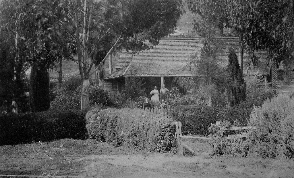
This is a restoration of a recently discovered circa 1878 photograph by Edward Teague (1843-1928). It depicts a family of four in front of their early Lyttelton cottage, probably in the vicinity of upper Selwyn Road, where Teague is recorded to have been living in that time. Below is another photograph of a Lyttelton house by Teague that is dated from the same period.


English by birth, but an Australian from the age of four months, Edward Teague is recorded as a gold miner at Waipori in the Tuapeka district in April 1867. Bankrupt two years later, in 1872 he married and established a photographic studio in the same town. By 1874 he was recorded as a photographer at Balclutha, where he also carried on the business of a Tobacconist and Hairdresser.

At the end of 1878 Teague relocated with his wife and three children to Lyttelton, occupying photographic premises in residential Selwyn Road until 1881, when he moved to Canterbury Street. By 1885 he is recorded as the proprieter of the London Portrait Rooms on London Street, with a further move (possibly residential) to Oxford Street in 1886.

By the following year he was bankrupt again and had moved to Westport. After a short sojourn in that township the family moved on to Greymouth, then returned to Australia in 1888.

By 1897 he was again recorded as a photographer at Greymouth, but had left New Zealand by early in the following year, establishimg himself as a photographer at Zeehan in Western Tasmania. Sill living in that town 1913, he is recorded as being a 72 year-old Miner. He died at Launceston on the 8th of October 1928 in his 85th year.


Also probably dating from the late 1870s is the only other known landscape photograph by Edward Teague. In a westerly view of Lyttelton's inner harbour, it depicts Dampier's Bay, then a popular bathing beach. The bay succumbed to reclamation in 1881 and two years later the extant graving or dry dock was built in the vicinity to the Left of the photograph.

Edward Teague kept no samples of his photography and apart from one photograph taken of his wife and her three sisters, no examples of his work remain with family members. But although business acumen may not have been among his strong points and churning out portrait cards may not have allowed much room for artistic expression, his rare landscapes attest to a genuine talent for composition and the use of light. Accordingly, he well deserves recognition for his contributions to early New Zealand photography.

Edward Teague specialised in producing cartes de visite in his Lyttelton studio. There are three examples known to be held by the National Museum of New Zealand, but they are not available on-line. A further eight of his cartes de visite can be viewed on the Early Canterbury Photographers web site

We're greatfully indebted to Steven McLachlan of the Shades Stamp Shop at 108 Hereford Street, Christchurch for the top photograph, which precipitated this article and also to Heather Bray of Dunedin for the biographical details of her great great Uncle.

Addendum

Yesterday, some cattle were being driven along Oxford street, Lyttelton, when one of them, being headed, turned into Mr Teague's (photographer) shop. Mr Teague, who was absent at the time, came up promptly, but the bull blocking the way, he could not effect an entrance. Mr Garforth, who happened to be on the spot, managed to get into the gallery, and, at no small risk to himself, seized the animal by the head and backed him out, fortunately before he managed to do any damage.
The Star newspaper 18 October 1883

Jun 10, 2009

Epitaph: John Grubb 1817-1898


As a member of the Canterbury Association's thirty-five strong initial work party, John Grubb, a thirty-two year old Scottish Carpenter arrived at Lyttelton on the 2nd of July, 1849.

His first responsibilty was the erection of the five prefabricated dwellings and Blacksmith's shop, carried from Wellington in the hold of the Fair Tasmanian. Three weeks later John commenced the construction of a 46 metre jetty, at which the first emigrants from the Association's chartered sailing ships would arrive 17 months later. Among those passengers were his wife Mary and their three daughters.


Early in the following year John Grubb built an extension across the front of what the historical record appears to indicate as being the 1849 prefabricated cottage of Joseph Thomas, the Principal Surveyor and Acting Agent of the Canterbury Association.

Initially granted a licence to occupy the site at the time when Captain Thomas relocateded to a more substantial dwelling, Grubb subsequently purchased the property for £23, when the set price for a bare section was £12.

By 1864 Mary and John's family included a further seven Lyttelton born children and an additional floor had been added to the 1851 extension.

Situated at 62 London Street, the house (below) remained in the Grubb family until 1961 and was purchased in 2006 by the Christchurch City Council for $260,000. We look forward to its restoration...


The mismanaged Canterbury Association collapsed in 1852 and John Grubb set himself up as a Shipwright on the foreshore (below foreground), in the vicinity of where the defunct second Railway Station now stands. A builder's model of John Grubb's Caledonia, the first vessel built of New Zealand timber and entirely by local industry, is in the collection of Canterbury Heritage.


Born on the 7th of November 1816, the former Mary Stott married John Grubb on the 26th of January 1842. She died at Lyttelton on the 18th of October 1886. Born on the 1st of May 1817 at Ferryport-on-Craig, Fifeshire, John survived his wife by a further twelve years. Lyttelton's oldest resident died in his 82nd year on Saturday, the 19th of February 1898.


The extensive and somewhat folkloric history of the Grubb family and their endeavours are well documented and thus the pioneering John Grubb can be considered as one of the seminal figures in the foundation of our community. That his final resting place in Lyttelton's Canterbury Street Cemetery lies ruined and forgotten might well seem to be a barometric indicator of our current cultural climate.

Jun 5, 2009

Sydenham Townhouse Minimalist Design


Inspired by the work of the Japanese Architect Kouichi Kimura, this is a design proposal for the renovation of a Sydenham factory as a townhouse.

Within the suburbs to the immediate south of central Christchurch are numerous small factories and warehouses with long term vacancies. Such a proposal allows for the cost effective recycling of a commercial building situated within walking distance of the inner city.

May 22, 2009

Trends in Domestic Architecture


Here in Christchurch we might not yet be able to enjoy the standards of domestic architecture as epitomised by this suburan dwelling in the Slovenian city of Ljubljana, but on the other hand we do have this opposite end of the aesthetic spectrum (below), situated in suburban Merivale.

May 10, 2009

Rare Survivor of Earliest Sydenham


The long derelict cottage at 3 Harold Street, Sydenham occupies the western part of Lot 67 on Deposited Plan 75 in the former Borough of Sydenham (1876-1903).

That the dwelling's site shares the same legal description as 35 Buchan Street indicates that it occupied a quarter acre section, which originally faced on to Buchan Street, with two recent commmercial premises now occupying what had formerly been its front garden.

Harold Street was known as Aynsley Street until 1948 and its environs probably formed a part of the investment properties of the pioneer merchant Hugh Aynsley (1828-1917), who subsequently rose to civic prominence as Hugh Percival Murray-Aynsley, Esq.

The cottage appears to have begun life in the 1850s as a simple two-roomed dwelling, with a later extension to the north in the same style. It's design suggests a kitset cottage imported from Australia, and that it survives in relatively sound condition in spite of decades of neglect, would appear to indicate the durabilty of Australian hardwoods.

The apparent era of construction predates the development of this part of Sydenham as a built-up residential district. It's therefore surmised that the cottage was probably either the residence of an early market garden or had been removed from the inner city as the pressure for commercial redevelopment began to overtake Christchurch's earliest residential areas.

A further eight photographs of the cottage by Dr Greg O'Beirne, of the University of Canterbury, can be seen as a set on his flickr web site.


Addendum:


LARGE IMAGE OPENS IN A NEW TAB OR WINDOW

From Early Canterbury Photographers comes this photograph by Hubert David Bettger (1873-1935), of a similar, but architecturally ornamented dwelling from a slightly later era. Named Mabe Cottage, it continues to survive at Olliviers Road, in the eastern suburb of Linwood.