Showing posts with label streetscape. Show all posts

Jul 27, 2009

Canterbury's First Fire Station


LARGE IMAGE OPENS IN A NEW TAB OR WINDOW

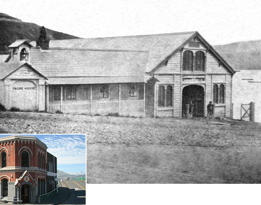
Photographed in August, 1862, this is a view of the three buildings occupying Lyttelton Town Section 33 to the eastern side of the access to the Canterbury Association's 1850 jetty. In 2009 it is the south-eastern corner of Norwich Quay, where the over-pass to the wharves begins just below the intersection with Oxford Street.


A similar view 147 years later

To the Right in the top photograph, at the south-eastern corner of the intersection is the Lyttelton Fire Station. Built in 1858, it preceeded the formal establishment of the Lyttelton Fire Brigade by four years.

Above the engine shed's front doors is the sign of the Liverpool, London and Globe Fire Insurance Company. That company shipped the engine, and the bell in the belfry above, from England to their Lyttelton agents.

Under the supervision of Thomas James Curtis, the Fire Brigade's Superintendent from 1862, the engine's steam powered pump could lift water, via a hose from the beach, three blocks north to Exeter Street.


From the rear in 1865

Next door, to the centre of the top photograph, is the 1852 premises of Bowler and Company. William Bowler (1803-1863), who lived in Sumer Road (just visible at the top Left of the top photograph), was a General Merchant and Shipping Agent. Bowler sent the first direct shipment of wool from Canterbury to London in 1856 and was subsequently owner of the paddle tug Lyttelton, which began service in the port from January, 1861.


Sketch detail: 1869 Royal Visit

Although the company's sign continues to indicate Bowler and Co., Isaac Thomas Cookson (1817-1881), agent for the Liverpool and London Fire Insurance Company had already entered into partnershp with Bowler, with the company's name becoming known as Cookson, Bowler and Company

The Fire Station and adjacent premises of Bowler and Company were demolished by 1880 to make way for the Lyttelton Harbour Board's extant former offices, currently occupied by The Harbourmaster's Café.

To the Right in the top photograph is the store of James Drummond Macpherson (1829-1894), built in 1859 on piers above the original beach. A Customs Agent, Lloyd's Agent, Ship owner, General Merchant, Coalmonger and Farmer, Macpherson was the first representative of Mathieson's Agency, a London company which shipped merchandise to the colony on consignment.


circa 1863

From 1864, using spoil from the railway tunnel construction, reclamation of the foreshore began. Five years later, with nearby soil quarried by prison labour, the beach in front of Scotsman's store disappeared beneath the site of the Port's first Railway Station.


circa 1908

The 1859 store became the Railway's offices and parcel shed, a role that it would continue to fulfil until 1963.


Overpass construction 1962

Knowing the price of everything, but nothing of heritage value, between 1965 and 1970 the Lyttelton Harbour Board set about the needless destruction of most of the historic buildings along the town's waterfront. James Macpherson's 1859 store was among the first to go. Its site remained vacant for 40 years, eventually succumbing to a nondescript concrete box in the neo-brutalist tradition.

The only surviving relic of Macpherson's ownership is the 1855 steam tug Mullogh, whose rusting bones now rest on Lyttelton Harbour's Quail Island.

Jul 21, 2009

Mountfort's 1863 Sketches of the 1850 Land Office

These are details from circa 1863 unfinished sketches, showing two views of the Canterbury Association's 1850 Land Office on the north-west corner of Oxford Terrace and Worcester Street. Adjoining Oxford Terrace on an east-west axis is the 1858 wing added to house the Magistrate's Court.


In the upper southerly view can be seen Davis's Hotel on the diagonally opposite corner, which began life as the 1851 home of the first Commissioner of Crown Lands and went on to eventually become the Clarendon Hotel. The lower northerly view shows the Canterbury Provincial Council buildings prior to the construction of the 1865 stone debating chamber.


The progressively enlarged Land Office became the first premises of the Christchurch City Council in 1864. Constructed of imported Australian Hardwoods, the province's first municipal building was demolished before March 1886 to make way for the extant Municipal Chambers, which can be seen to the centre foreground in the upper, and to the Right in the lower, of the following photographs.


Attributed by us to Christchurch's pre-eminent Gothic revival architect Benjamin Mountfort (1825-1898), and probably intended as preparatory to watercolour paintings, the original pencil sketches can be dated as being after 1861, as in full they show Mountfort's belfy for the St. Michael and All Angels church on Oxford Terrace.


The incorrectly identified Alexander Turnbull Library references:
Artist unknown: Flax & Maori heads, toe toe, &c; flax, tutu, fern, &c [ca 1872-1874?]
Reference number: C-081-009
1 drawing(s). Pencil drawing, 265 x 657 mm.. Horizontal image.
Part of Artist unknown :[Eight pencil sketches of Christchurch buildings and the Avon River. 1870-1875?] (C-081-003/009)
Drawings and Prints Collection, :
Scope and contents: Shows a section of the Avon River with several flax bushes in the foreground, and a flat bridge at the right. There are several house at the centre and left, and St Michael and All Angels Church (built 1872) is in the centre background, with the Port Hills of Christchurch in the distance.

Artist unknown :[Provincial Council Chambers, Christchurch. 1870-1875?]
Reference number: C-081-003
1 drawing(s). Pencil drawing, 240 x 410 mm.. Horizontal image.
Part of Artist unknown :[Eight pencil sketches of Christchurch buildings and the Avon River. 1870-1875?] (C-081-003/009)
Drawings and Prints Collection, :
Scope and contents: Shows the Provincial Council Chambers in the distance, seen past a house with a verandah at the left, and a fenced area of trees at the right.

Jul 13, 2009

Chancery Lane 1862


LARGE IMAGE OPENS IN A NEW TAB OR WINDOW

This is an extensive reconstruction of a circa 1862 pencil sketch of three buildings on the southern side of Gloucester Street West at the location where Chancery Lane has been situated since 1882. The depiction of the side wall of the building to the Left remains in its original state to indicate the condition of the poorly conserved original. Below is the same location, opposite the Christchurch Central Library, as it appears in 2009.


Situated on Town Sections leased from the Revered James Wilson (1831-1886), Archdeacon of Akaroa, are the homes and business premises of three families, whose fathers would rise to prominence in the city and sire 25 children between them. Statistical extrapolation would suggest that by 2009 they would have about 18,000 living descendants.


It's possible to date the drawing to between 1861 and 1863 consequential to the two photographs above. The earlier image indicates that the buildings at each side of the drawing were still single-storey structures and that the central building was yet to be fitted with its glazed veranda.


At the Left of the partially completed drawing, which is annotated with "extend on both sides," is the two-storey premises of the painter, paperhanger and glazier William Epthorp Samuels (1833-1917). His wife Eliza would bear a son and ten daughters.

Arriving from Sydney in 1859, Bill Samuels would be one of the founders of the Christchurch Fire Brigade in the following year. By 1864 he is recorded as the Publican of the White Swan Hotel on the southwest corner of Tuam and Montreal Streets. By the late 1860s the Samuels had moved to Thames, where Bill is recorded as a bankrupt hotel keeper in 1870.

The family returned to Christchurch after six years in the Goldfields district and by the 1880s Samuels is recorded as having achieved some prominence in the United Ancient Order of Druids. In 1891 his occupation was stated as Artist. A Justice of the Peace and Christchurch City Councillor from 1894 to 1905, Samuels lived to the age of 84 and is buried in the Barbadoes Street Cemetery


Elizabeth and John Coe (1832-1893) had established themselves at Lyttelton by 1855. John operated a liverly stables next door to the Mitre Hotel in Canterbury Street and, adjacent to the stables, Elizabeth opened a Millinery shop, with their accommodation above. Also a provincial government contractor, John established the first coach service from Christchurch to Lyttelton. By 1857 Christchurch had begun to rival its Port in size, the writing was on the wall as far as commercial development was concerned, and in 1859 the Coes moved to the new city.


With the architect Isaac Luck (1817-1881) favouring the the Tudoresque style of architecture and his partner Benjamin Mountfort (1825-1898) tending to the Gothic alternative, Elizabeth Coe's 1859 Millinery Establishment (above) at the centre of the drawing is probably to the design of the latter. The subject matter, artistic style, architectural accuracy of the buildings and the hand written annotations on the drawing would tend to support an hypothesis that it could be an unattributed sketch by Mountfort.

The Coes prospered to the extent that in 1866 John was able to purchase 1,640 acres at Irwell in the Ellesmere district to the near south of Christchurch. Here they built Bruscoe Lodge, a two-storey home with sixteen rooms. One of their many grandaughters married the renowned artist Sydney Lough Thompson (1877-1973), and a direct descendant is Mayor of the Selwyn district in 2009. Probably familiar to most Canterbrians is Coes Ford, a popular recreational reserve near Irwell that takes its name from these early settlers in the district.


To the Right of the drawing is the 1858 home of Sarah Elizabeth and Joseph William Papprill (1801-1880), who had come to Christchurch in 1856. By 1864 the building had acquired a second storey to accomodate the first seven of their eventual nine children. A Tailor and Habit maker by trade, Papprill sold the Gloucester Street business in 1873 to an employee and was describing himself as a Gentleman by the following year.

Joseph lived to the age of 79 and is buried in the Barbadoes Street Cemetery. His eldest son entered the legal profession and a grandson succeeded to the Practice, which continues to prosper in 2009 as Papprill Hadfield & Aldous.


The renowned doctor and pioneer photographer Alfred Charles Barker (1819-1873) reminisced that the alley way between Elizabeth Coe's Millinery and Joseph Papprill's Tailor's shop had been a popular short cut for revellers in the 1860s, who disturbed his evening tranquility.


By 1881 the last of the Venerable Archdeacon's 21 year leases expired and the structures depicted in the drawing were demolished to make way for a matching pair of buildings on either side of the Alley (above). which became officially known as Chancery Lane. The last surving remnant of these is the eastern third of the building to the Right of the Lane (below).


Addendum

Chancery Lane 1960


The Alexander Turnbull Library reference:
Artist unknown :[Three shops in Gloucester Street, Christchurch. 1870s]
Reference number: C-081-004-2
1 drawing(s). Pencil drawing on sheet, 240 x 535 mm.. Horizontal image.
Part of Artist unknown :[Eight pencil sketches of Christchurch buildings and the Avon River. 1870-1875?] (C-081-003/009)
Part of Artist unknown :[Two Christchurch sketches; Slate roofed stone house; and, Three shops in Gloucester Street. 1860-1870s] (C-081-004)
Drawings and Prints Collection, :
Scope and contents

Notes

Shows three businesses, probably in Gloucester Street, Christchurch: a painter's and glazier's business; Albion House Millinery; and [T] Papp[rill tailors].

Location Gloucester Street assumed from the fact that T Papprill, tailor is listed as being in Gloucester Street in Wises Directory for 1872.

Jul 8, 2009

Christchurch 1864: Oxford Terrace Streetscape Identified


Viewed from Cambridge Terrace, this is an extensive restoration of a remarkably accurate 1864 pencil sketch of Oxford Terrace between Worcester, Hereford and Cashel Streets. Below it is a similar view as it appears in 2009.

Lurking in the on-line archive of the Alexander Turnbull Library, it's described as "Bridge and houses, Avon River, Christchurch. 1870-1875?" By an unknown artist, the original is extensively annotated, probably indicating that it was intended to be a preliminary sketch for a painting.

This is one of a series of eight pencil sketches by the same unidentified artist. The subject matter, artistic style, architectural accuracy of the buildings and the graphological evaluation of the hand written annotations would tend to support an hypothesis that they could be the unattributed work of Benjamin Woolfield Mountfort (1825-1898).


To the foreground is the Worcester Street footbridge. Constructed in February, 1851, it was replaced in 1864 by a wider bridge for wheeled traffic.


To the far Left is the 1851 house of William Guise Brittan (1807–76), the Commissioner of Crown Lands. First premises in which the provincial government met, by the time of the sketch it formed the earliest part of Davis's Hotel. It would be much enlarged after 1864, the year after Rowland Robert Teape Davis (1807-1879) sold out to George Oram (1826-1876) and moved to Heathcote.


Davis's hostelry was renamed as the Lyttelton Hotel, when the above 1858 extension was built. Eventually joined to the former Brittan house by a substantial wing, the hotel was renamed as the Clarendon in 1868. Progressively demolished in 1903-4 it was replaced by a stone building, the facade of which survives below the 1987 Clarendon Tower. The height of the nearby tree and the residential development along Oxford Terrace towards Cashel Street confirm the ascribed date.


At the norther corner of Hereford Street is a commercial building, the earliest origins of which are yet to be ascertained. Occupied by many tenants, it's recorded as being the premises of a Fishmonger, Cabinetmaker, Tailor and Taxidermist at various times.


In Hereford Street can be seen the circa 1859 two storey townhouse of Riccarton farmer John Shand (1805-1874), Subsequently Solicitor's offices and now known as Shand's Emporium, it's the only building in the sketch to have survived.


On the southern corner of Hereford Street and Oxford Terrace is the August 1854 offices of Joseph Brittan's Canterbury Standard newspaper. The city's first evening paper, it ceased publication in 1860. Subsequently the Standard Hotel, the building was moved to Bealey Avenue in 1868.


Granted a 30 year lease in 1858 on what is still known as Mill Island is David Inwood's water-wheel powered grain Mill. A night shelter for the city's homeless from 1889, it was demolished in 1897.


The Alexander Turnbull Library reference:
Artist unknown :[Bridge and houses, Avon River, Christchurch. 1870-1875?]
Reference number: C-081-005
1 drawing(s). Pencil drawing, 240 x 410 mm.. Horizontal image.
Part of Artist unknown :[Eight pencil sketches of Christchurch buildings and the Avon River. 1870-1875?] (C-081-003/009)
Drawings and Prints Collection

Jul 6, 2009

Where is the Statue of Apollo Now?


"Yesterday one of the largest blooks of stone from any of the local quarries was delivered at Mr D. Reese's yard, St Asaph Street west, from the White Rock quarries. The stone, which is 10 feet 4 inches by 4 feet 1 inch by 2 feet 4 inches, is to be carved into a figure of Apollo, to be placed on the pediment of Messrs Milner and Thompson's new music warehouse, now in course of erection in High street."

The Star, 27 February, 1883.


"The elevation of the stone figure of Apollo to the pediment of Messrs Milner and Thompson's new music warehouse was the occasion of some excitement, and caused a considerable crowd to collect in front of the building this afternoon. In order to provide against the musical divinity suffering any personal injury during the ascent he was enclosed in a sort of cage, and protected by swathing bands of canvas. The figure was successfully hoisted and lowered into position about 2.30 p.m."
The Star, 16 April 1883


In 1874 Robert Henry Thompson (1835-1915) and Benjamin Milner established the Canterbury Music Depot on the north-east corner of High & Cashel Streets.

Manufacturers and Importers of Pianos and Organs and General Musical Warehousemen, they prospered to the extent that nine years later they were able to erect a three storey stone building next door. For the pediment of their new premises they commissioned a statue of Apollo, the god of music from classical antiquity.


The business continued to expand and in 1895 moved to much larger premises on the corner of Bedford Row and Manchester Streets (that building, next to the former Majestic Theatre, barely survives in a derelict condition, behind a 1930s facade).

It's likely that the Apollo statue was moved with the company, but was not placed on the pediment of the newer showrooms. The circa 1930 photograph below shows Milner and. Thompson's 1883 building, with the statue removed, occupied by the photographic supplier and chemist Wallace and Company.


By the 1980s the High Street building had fallen prey to the Southland Building Society. Below: stripped of its cornice and some of the architectural ornamentation, the stone facade was painted in garish colours.


Surviving into its third century, the old building is currently the premises of Quest, purveyors of lifestyle attire and accessories for those of the alipne persuasions.


Thanks to Sarndra for asking the question, for which the above is the answer.

Jul 4, 2009

Same View Over 158 Years

Covering a period of 158 years, these are five southerly views of Colombo Street from the vicinity of Victoria Square.


1851


1868


1882


1949


2009

May 30, 2009

A Unique Photographic Discovery


Streetscapes of Christchurch in 1868 are quite rare; there are only ten that can be positively identified to that specific year, with another four being designated as circa 1868. Accordingly, we were pleasantly surprised when our hawk-eyed scrutiny revealed that a pair of these 141 year-old photographs were taken within minutes of each other and almost certainly by the same photographer.

In that era hand held cameras were still a far off dream and the bulky equipment would have necessitated the use of a tripod as the exposure time for a sun lit landscape would then have been about five seconds. What can be ascertained by the digital interpolation of the photographs with variable transparency, is that although they were taken from the same vantage point, the camera's lens had been changed between the exposures, with the second photograph probably being taken with a portrait lens.

The pair of photographs, which would appear to be unique in the annals of early Christchurch photography, were taken from the intersection of Oxford Terrace and Cashel Streets (near to where the Bridge of Remembrance now stands). In these northerly aspects across Hereford to Worcester Street, the horse and cart to the Left has moved on in the second photograph and the man standing on the pavement to the Right has turned his back to the camera.

As yet unable to positively identify the photographer, our best guess would currently be Alfred Barker, that renowned gossip, city Coroner and pioneer of Christchurch photography. His enthusiasm for amateur photography would not only be in keeping with an experimentation of the same subject, but he was also said to have cut up window panes from his house (which is not quite visible in the photographs) in order to make more glass negatives.

In that era our common coins, from threepences to half-crowns, were made of 92.5% Silver. These could be dissolved in Nitric acid, with the resulting silver nitrate salts then mixed with Gelatine (derived from animal bones), which would then be used to coat one surface of the 165 by 216 millimetre glass plates.

In order to wash the exposed negatives, Dr Barker would leave them in a box in the Avon River overnight. His journal mentions the ongoing problem of their being stolen from the river during the hours of darkness. Perhaps these unattributed photographs were among his losses.

We've come a long way since the observation that silver tarnished in sunlight led to the invention of viable photography. Thanks to the architect Benjamin Mountfort, who taught photography to Alfred Barker, the photographic record of our city's development began within three years of its foundation.


The same view as it appears in 2009

May 21, 2009

Christchurch's A.1. Hotel 1857-1935


Founded in January 1851, the Lyttelton Times newspaper also published an evening edition known as The Star from 1868. More widely read in Sydenham than Fendalton in its heyday, the evening edition lingers on as a twice weekly giveaway, supported by no more than advertising and Christchurch City Council advertorials.

Sad to say that its reduced circumstances would seem to no longer allow for the expense of journalstic expertise, as further indicated by the above photograph, published under the heading The Way We Were on the 20th of May 2009, and erroneously captioned "The intersection of Cashel St and Colombo St in 1860, with Blake's Hotel and the A.I Hotel around the corner."

For the sake of the historical record we proffer the following alternative caption:

The A.1. Hotel was founded in 1857 on the Southeast corner of Cashel and Colombo Streets, a site now occupied by The Crossing bus terminus in the renovated former Beath's department store building of 1935. The original gabled hotel (below) was replaced in 1874 by the second A1 Hotel, a three storey building, which burnt down four years later.

In 1879 it was rebuilt as the two storey structure depicted in the above photograph. James Blake is known to have been the Publican of the A.1. Hotel by 1865, but there's no known reference to a Blake's Hotel in any local archive.


The Colombo Street facade of James Blake's first A.1. Hotel to the Left, with the Mechanic's Hotel to the Right and the Watchmaker's shop of Thomas Charles Barnard adjoining the A.1. Hotel.

By 1915 the ground floor of the third A.1. Hotel had been converted into shops


Beath's 1935 department store extension was originally designed to have six floors, but The Great Depression of the 1930s got in the way.


Beath's department store reincarnated as The Crossing bus terminus in 2003.

May 20, 2009

Newtown, Christchurch


A source of confusion to family historians are references to the Christchurch suburb of Newtown, often mistaken for the Wellington suburb of the same name.

Newtown was the original name for Sydenham. Although constituted as the Sydenham Borough in 1877, the original name was still in common use three years later.

A 126 acre residential subdivision dating from 1861, by 1885 the borough comprised 45 kilometres of formed streets and a population of 9,500. The later name appears to derive from the Sydenham Academy, listed in 1860 as the Tuam Street school of Charles Prince (public schools were not established in Christchurch until the 1870s - it was not deemed necessary to educate the children of the labouring classes in the first two decades of settlement).

The above photograph is a southerly view of Colombo Road, Newtown (subsequently to become an extension of Colombo Street). In the middle distance can be seen the extant 1877 Wesleyan Methodist church at the corner of Brougham Street. Below is an 1877 envelope adressed to the recipient at the Newtown Post Office, Christchurch.


Addendum


A mud brick (cob) cottage built on the northern side of Brougham Street East in the year following the original 1861 subdivision. It was demolished after 1912, when the photograph was taken.

Apr 17, 2009

Early Christchurch Electric Vehicles

The diasporical and widely appreciated The New Zealand Journal has recently featured a short post entitled Christchurch City Council Belt-Tightening?, in which it's wondered if there might be any advantage to the Council ordering up from storage its electric truck fleet from the early 1920s, which could have the advantage of enabling the Council to meet its greenhouse gas emissions reductions. The post includes this Alexander Turnbull Library image by The Press newspaper photographer Samuel Heath Head.


LARGE IMAGE OPENS IN A TAB OR NEW WINDOW

By 1915 the Council's Municipal Electricity Department in Armagh Street was charging car batteries overnight, when cheaper off-peak rates were offered between 10 pm and 7 am. The two 100 Kilowatt generators were driven by a pair of steam engines powered by the Council's refuse destructor. In 1921, at the peak of their popularity, the M.E.D. was charging the batteries of 51 vehicles, of which 40 were privately owned, with the other 11 belonging to the Council. The City Council's Municipal Electricity Department even offered hire-purchase agreements to assist companies and individuals to purchase electric vehicles.


LARGE IMAGE OPENS IN A TAB OR NEW WINDOW

In this elevated westerly view of Bealey Avenue near the Carlton Mill Bridge can be seen the city's entire fleet of electric vehicles. The photograph can be dated to 1926 by the construction of the extent Fleming House at the corner of Park Terrace (Left).


Above: photographed on Park Terrace is the circa 1922 American Walker electric lorry of Wardell Brothers, the Cashel Street Grocers. To the Left is the extant 1915 Summers house. Below: also at the same location is the electric lorry of Sharpe Brothers, aerated water and cordial manufacturers. Both of these photographs were also taken by Samuel Heath Head.


Photo credits:

1926 electric vehicle fleet; Municipal Electricity Department archive, Orion New Zealand Ltd

Sharpe Brothers lorry; Alexander Turnbull Library, reference number: 1/1-011062-G

Wardell Brothers lorry; Alexander Turnbull Library, reference number: 1/1-007411-G