Dec 11, 2008

Recent Photographic Acquisitions

Some previosly unpublished, restored and geo-tagged images of old Christchurch that have recently been added to the archive.


An 1883 northery aspect of Colombo Street from near the northwest corner of Cashel Street. The view is across The Bottleneck at the junction with Hereford and High Streets. To the far Left are the premises of the Confectioner Thomas Gee, who would later occupy the northeast corner of Colombo Street at Cathedral Square as the Broadway Tea Rooms.


This is a circa 1877 photograph of the Botanic Gardens on Rolleston Avenue. Taken from near the main gates of the gardens, it is a southerly view towards the 1866 South Lodge, home of the Botanic Garden's first Curator John Francis Armstrong (1840-1902). The lodge was replaced by the extant Curator's House in 1919. Beyond it can be seen the early buildings of the Christchurch Hospital.


A circa 1875 view of the 1858 Ohinetahi homestead at Allandale, Governors Bay on Lyttelton Harbour. Built by Thomas Henry Potts (1824-1888), it is the home of the Architect Sir Miles Warren in 2008.


A circa 1875 southeasterly view of the 1859 water mill, situated where the Hereford Street bridge on the Avon River now stands. The Mill was demolished in 1897.


A pair of photographs depicting St Michael's Church and Vicarage on Oxford Terrace at the junction of Lichfield and Durham Streets. The circa 1885 photographs are attributed to Alfred V. Gadd (1833-1910), whose London Portrait Gallery was active from 1876 to 1893.

A part of the photograph showing the winter scene was published in Gwenda Turner's 1999 book Christchurch - An Enchanted Journey Through the Garden City.


An elevated northeasterly view from the tower of Ward's Brewery on Fitzgerald Avenue. Taken about 1885, it includes Avonside Drive and River Road. To the lower Right foreground is the extant 1852 Englefield Lodge (the city's oldest house). This photograph currently forms the Right hand end of an eight photograph panorama from the brewery tower, which will be published when the missing two photographs have been located.


Known as the Ilam homestead, this huge house began life as a pair of joined kit set houses bought from England in 1858 by John Charles Watts Russell, J. P. (1826-75). Originally situated on a fifty acre rural block between Fendalton Road and the Deans farm, two branches of the Waimairi stream passed through the ten acres of gardens (below).


In 1866 John Russell sold most of his property and returned to England, He came back to Christchurch in 1871, where he died four years later aged 49 years and is buried in St Peter's Churchyard at Upper Riccarton.

Mrs Russell subsequently married A. R. Creyke and the Ilam land was subdivided in 1880. Later owners of the property included Leonard Harper, "Ready Money" Robinson, Patrick Campbell and G. D. Greenwood, but what had been the largest private residence in Canterbury was destroyed by fire in August, 1910. 

Edgar Stead rebuilt the house in 1914 and also developed a renowned Azalea and Rhododendron garden. Stead sold the property to the University of Canterbury and his home is now the University's Staff Club.

Photographic Excellence


LARGE IMAGE OPENS IN A NEW WINDOW

An elevated northerly view from Redcliffs, across the Avon-Heathcote estuary, to New Brighton.

Photographed by moonlight on the evening of the 10th of December, 2008 by Andrew McGregor.

Dec 8, 2008

The Oxford Hotel


Situated on the northeastern corner of Colombo Street and Oxford Terrace at Victoria Square, the simple structure to the centre foreground of the above photograph had the distinction of being the first building erected within the original boundaries of the city of Christchurch.

Built by April 1850 on Public Reserve No.1, it was the Canterbury Association's store. From here were issued the victuals and equipment to the men building the jetty on Oxford Terrace at Barbadoes Street and the Land Office on the northwest corner of Oxford Terrace and Worcester Street. The store probably owed its location to the nearby lagoon in which boats of up to twenty metres in length could be turned.

In 1853 the adjacent Christchurch Common became Market Place and the Association's store was in use as hostel for the Māori bringing produce from Kaiapoi, Rapaki and Port Levy to the weekly farmers' markets. By the beginning of the 1860s the former store was being used as their meeting hall by the United Methodist church.


The twelve year old store building was replaced in 1862 by the Boarding House by Antill Alfred Adley (1832-1911). Adley (above) had been granted a Publican's Licence by 1865, and his premises (below) became the sixth hotel to overlook the market place. The tall entrance to the Left led through to Stables and a small paddock on what would become the site of the city's third fire station in 1876.


Adley sold his hotel in 1873 and by 1881 the shingled roofed wooden building had been replaced by the current premises (below).


After undergoing substantial modification in 1978 (below), the old hotel became known as the Oxford Tavern. Now known as the Oxford on Avon, it houses two bars and a pair of popular restaurants.


Below: overlooking the site from where passengers embarked in excursion paddle steamers to New Brighton and Sumner in the 1890s, is the alfresco terrace of The Carvery Restaurant.


Dec 7, 2008

Historic Christchurch House For Sale


Had one a spare three and a half million spondulicks clogging the Till, then the 1910 home of Thomas Tayspill Dowling could be a handy solution.

A Tasmanian Shagroon, Dowling (1841-1920) was a retired farmer of the Oakleigh Estate at Southbridge, and built his six bedroom house at north Fendalton (a.k.a. Bryndwr), from where his five sons attended the Presbyterian St Andrew's College in Papanui Road.


Situated among almost five hectares of grounds, the house passed to the General Practitioner Dr David MacMillan in 1928. The MacMillan family retained the property until five years ago, when it was sold to the current owners.

Now named Hatherley Park, with armorial bearings and interior desecration to match, the house has its own web site, which opens in a new window...

The Political Manipulation of History


LARGE IMAGE OPENS IN A NEW WINDOW

The history of New Zealand and Canterbury in particular would appear to be awash with half-truths and misrepresentations that are endlessly repeated by everyone from professional historians to journalists.

Among the earlier examples of this ongoing practice is a map of Christchurch alleged to have been completed by the Assistant Surveyor Edward Jollie on the 18th of March, 1850.

This map contains some significant anomalies in the form of much information that didn't exist before 1853:
Referred to in early correspondence as Christchurch Common, and now known as Victoria Square, the site of the first encampment by the original settlers was not renamed as Market Place until 1853.

Cathedral Square was not acquired for such purpose until 1857 and was known as Ridley Square in 1850.

Jollie's original map did not include the 1851 de facto thoroughfares of Victoria and High Streets. The alleged map shows Victoria Street as Whatley Road. The was first known as the Papanui Road and did not acquire the name of the Anglican Bishop of Dublin until after the election of the Irish Protestant James Edward Fitzgerald as the Canterbury Provincial Council's first Superintendent in 1853. Fitzgerald attracted much criticism for his cronyism and conflicts of interest, practises that might still appear to prevail.

The Dissenter's cemetery on the western side of Barbadoes Street at Salisbury Street is not shown on a map named The Town of Lyttelton otherwise Christchurch and dated eighteen months after Jollie's survey.

There also many other discrepencies, but probably the most disturbing is the signature of Joseph Thomas, Chief Surveyor to the Canterbury Association. By the earliest time that the map could have been drawn Thomas had returned to England.
The map is a forgery in order to provide legal status for building on the public reserves and also for the subdivision of three of the green belts that surrounded the original city (first known a West Town Belt, the fourth would later be named Hagley Park, with what is now Deans Avenue being named Town Belt West).

In February, 1854 the Solicitor Henry Sewell (subsequently Prime Minister of New Zealand) advised the Canterbury Provincial Council that the sale of the city's green belts and public reserves was illegal. A year later wise counsel was ignored and 170 acres were offered for sale by auction on ten percent deposit, with the balance on a 7 year term.

But lest one consider that historical revisionism is ancient history, it should be noted that the Christchurch City Council recently erected an interpretive display board within the cultural precinct.


Amongst the information that it conveys to the visitor is the revelation that Christchurch is in fact a 700 year old community originally known as Puari, with a population of about 800.

There's no historical evidence for this assertion, which would appear to be yet another instance of historical revision.

Puari was a large settlement at Port Levy on Banks Peninsula. Known to European Whalers from 1794, the population had declined to about 300 Māori and 12 Europeans by the mid 1840s.

Dec 6, 2008

Christchurch Recycling Website

Not yet local history, but an interesting social phenomenon, is the Christchurch Freecycle 'net site (link opens in a new window).

Currently with 979 members, the non-profit group is open to all who want to recycle something rather than throw it away. Membership of Yahoo groups is requisite and everything posted to the group must be free.

Although an RSS feed is yet to be available, notification of about five posts a day can be received by individual emails or daily digests.

Dec 4, 2008

The Garrick Hotel

Almost certainly named after the famed British actor David Garrick (1717-1779), John Fielder's Garrick Hotel was built on the northeast corner of Colombo and Kilmore Streets before 1862. By 1864 an extension along Kilmore Street doubled the size of the two storey wooden building (below).


At some time after 1883, but probably before 1890, the original structure was replaced with a brick built hotel and by 1928 the name had been changed to the Waverley Private Hotel (below).


Diagonally opposite the Christchurch Town Hall and shorn of its ornamentation and cornice, the sadly nondescript building is now barely noticed by the casual passer by (below).

1860s Canterbury Transport


LARGE IMAGE OPENS IN A NEW WINDOW

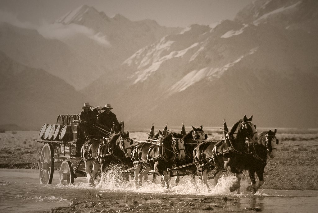
With Mount Cook in the background, an 1860s six-in-hand Brewer's wagon crosses the braided Rangitata River on a northward journey to Christchurch.

1864 & 1928


A pair of elevated north-easterly views across Victoria Square from the Armagh Street tower of the Canterbury Provincial Council buildings.

In the foreground of the earlier image are the Provincial Council's workshops and stables, which were replaced by the extant Magistrate's Court buildings from 1869 to 1881.


Credits
1864 photograph: Anthony Rackstraw (Early Canterbury Photographers).

1928 photograph: Alexander Turnbull Library (Ref. No. 
PAColl-5800-04).

Dec 3, 2008

Street Photographers


With the introduction of the 35mm Leica portable camera in 1925, candid street photographers became a common sight in Christchurch's Cathedral Square until the early 1960s.

In this typical example of their work is a then unknown 20 year-old, photographed with his parents as they pass the Cathedral in a southerly direction.

More familiarly known as plain Bill, Sir Wallace Edward Rowling KCMG, (1927-1995) would become the Member of Parliament for Fendalton in 1960 and then Prime Minister of New Zealand in 1974.